Geolocate

Big Spring topographic map

Click on the map to display elevation.

About this map

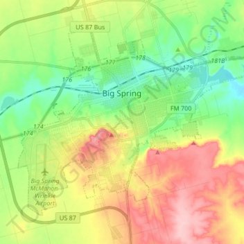
Name: Big Spring topographic map, elevation, terrain.

Location: Big Spring, Howard County, Texas, 79720, United States (32.19339 -101.53611 32.28066 -101.40186)

Average elevation: 781 m

Minimum elevation: 719 m

Maximum elevation: 867 m

Gear up for your next adventure:

🧢Sun Hat - Wide-brim hat for sun protection
🥾Hiking Gaiters - Protect legs and shoes from mud, snow, and debris
Camping Essentials - All-in-one gear for a comfortable camping trip
🥾Trail Running Boots - Durable shoes designed for trail running
🧴Outdoor Sunscreen - High SPF protection for high-altitude UV exposure

As an Amazon Associate, this site earns from qualifying purchases at no extra cost to you.