
Hudson Bay topographic map
Interactive map
Click on the map to display elevation.
About this map
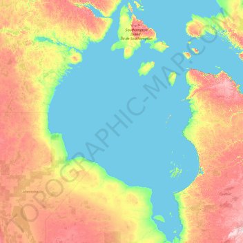
Name: Hudson Bay topographic map, elevation, terrain.
Location: Hudson Bay (54.63208 -94.85700 64.11375 -76.62038)
Average elevation: 35 m
Minimum elevation: -1 m
Maximum elevation: 347 m
From the large quantity of published geologic data that has been collected as the result of hydrocarbon exploration, academic research, and related geologic mapping, a detailed history of the Hudson Bay basin has been reconstructed. During the majority of the Cambrian Period, this basin did not exist. Rather, this part of the Canadian Shield area was still topographically high and emergent. It was only during the later part of the Cambrian that the rising sea level of the Sauk marine transgression slowly submerged it. During the Ordovician, this part of the Canadian Shield continued to be submerged by rising sea levels except for a brief middle Ordovician marine regression. Only starting in the Late Ordovician and continuing into the Silurian did the gradual regional subsidence of this part of the Canadian Shield form the Hudson Bay basin. The formation of this basin resulted in the accumulation of black bituminous oil shale and evaporite deposits within its centre, thick basin-margin limestone and dolomite, and the development of extensive reefs that ringed the basin margins that were tectonically uplifted as the basin subsided. During Middle Silurian times, subsidence ceased and this basin was uplifted. It generated an emergent arch, on which reefs grew, that divided the basin into eastern and western sub-basins. During the Devonian Period, this basin filled with terrestrial red beds that interfinger with marine limestone and dolomites. Before deposition was terminated by marine regression, Upper Devonian black bituminous shale accumulated in the south-east of the basin.
Other topographic maps
Click on a map to view its topography, its elevation and its terrain.
Canada
Canada
Average elevation: 254 m
Vancouver
Canada > British Columbia > Metro Vancouver Regional District
Vancouver, Metro Vancouver Regional District, British Columbia, Canada
Average elevation: 34 m
Metro Vancouver Regional District
Metro Vancouver Regional District, British Columbia, Canada
Average elevation: 343 m
Edmonton
Canada > Alberta > Division No. 11
Edmonton, Division No. 11, Alberta, Canada
Average elevation: 690 m
Montreal
Canada > Quebec > Urban agglomeration of Montreal
Montreal, Urban agglomeration of Montreal, Montreal (administrative region), Quebec, Canada
Average elevation: 29 m
Surrey
Canada > British Columbia > Metro Vancouver Regional District
Surrey, Metro Vancouver Regional District, British Columbia, Canada
Average elevation: 28 m
West Vancouver
Canada > British Columbia > Metro Vancouver Regional District
West Vancouver, Metro Vancouver Regional District, British Columbia, Canada
Average elevation: 384 m
Victoria
Canada > British Columbia > Capital Regional District
Victoria, Capital Regional District, British Columbia, Canada
Average elevation: 17 m
Vernon
Canada > British Columbia > Regional District of North Okanagan
Vernon, Regional District of North Okanagan, British Columbia, Canada
Average elevation: 676 m
Mississauga
Canada > Ontario > Peel Region
Mississauga, Peel Region, Golden Horseshoe, Ontario, Canada
Average elevation: 151 m
Regina
Canada > Saskatchewan > Division No. 6
Regina, Division No. 6, Saskatchewan, Canada
Average elevation: 582 m
Quebec
Canada > Quebec > Urban agglomeration of Québec
Quebec, Urban agglomeration of Québec, Capitale-Nationale, Quebec, Canada
Average elevation: 117 m
North Vancouver
Canada > British Columbia > North Vancouver
North Vancouver, Metro Vancouver Regional District, British Columbia, V7M 1H9, Canada
Average elevation: 258 m
Sunnyvale
United States > California > Santa Clara County
Sunnyvale, Santa Clara County, California, United States
Average elevation: 24 m
Saskatoon
Canada > Saskatchewan > Division No. 11
Saskatoon, Division No. 11, Saskatchewan, Canada
Average elevation: 504 m
Chilliwack
Canada > British Columbia > Fraser Valley Regional District
Chilliwack, Fraser Valley Regional District, British Columbia, Canada
Average elevation: 240 m
Westchester County
Westchester County, New York, United States
Average elevation: 95 m
Santa Monica
Santa Monica, California, United States
Average elevation: 30 m
Peterborough
Canada > Ontario > Peterborough
Peterborough, Ontario, K9H 7E8, Canada
Average elevation: 235 m
Lubbock
United States > Texas > Lubbock County
Lubbock, Lubbock County, Texas, United States
Average elevation: 983 m
Saint John
Canada > New Brunswick > Saint John
Saint John, Saint John County, New Brunswick, Canada
Average elevation: 39 m
Colorado Springs
United States > Colorado > El Paso County
Colorado Springs, El Paso County, Colorado, United States
Average elevation: 2,252 m
Nelson
Canada > British Columbia > Regional District of Central Kootenay
Nelson, Regional District of Central Kootenay, British Columbia, Canada
Average elevation: 1,325 m
Kitchener
Canada > Ontario > Region of Waterloo
Kitchener, Region of Waterloo, Ontario, Canada
Average elevation: 336 m
Lethbridge
Canada > Alberta > Lethbridge
Lethbridge, City of Lethbridge, Alberta, T1J 4L3, Canada
Average elevation: 918 m
Prescott
United States > Arizona > Yavapai County
Prescott, Yavapai County, Arizona, United States
Average elevation: 1,674 m
Waterloo
Canada > Ontario > Region of Waterloo
Waterloo, Region of Waterloo, Ontario, Canada
Average elevation: 341 m