
Willow Creek Provincial Park topographic map
Interactive map
Click on the map to display elevation.
About this map
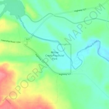
Name: Willow Creek Provincial Park topographic map, elevation, terrain.
Average elevation: 1,064 m
Minimum elevation: 1,034 m
Maximum elevation: 1,119 m
Other topographic maps
Click on a map to view its topography, its elevation and its terrain.
Head-Smashed-In Buffalo Jump
Canada > Alberta > Municipal District of Willow Creek No. 26
Average elevation: 1,115 m