Geolocate

Village of Bittern Lake topographic map

Interactive map

Click on the map to display elevation.

Village of Bittern Lake topographic map, elevation, terrain

Village of Bittern Lake topographic map, elevation, terrain

About this map

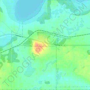
Name: Village of Bittern Lake topographic map, elevation, terrain.

Location: Village of Bittern Lake, Division No. 10, Alberta, Canada (52.98886 -113.07605 53.01808 -113.02759)

Average elevation: 746 m

Minimum elevation: 734 m

Maximum elevation: 773 m

Routes: Division No. 10 GPS tracks, routes, trails, hikes

Other topographic maps

Click on a map to view its topography, its elevation and its terrain.

Village of Innisfree

Canada > Alberta > Division No. 10

Average elevation: 679 m

Meeting Creek

Canada > Alberta > Division No. 10

Average elevation: 763 m

Bashaw

Canada > Alberta > Division No. 10

Average elevation: 796 m

Town of Vegreville

Canada > Alberta > Division No. 10

Average elevation: 638 m

Village of Myrnam

Canada > Alberta > Division No. 10

Average elevation: 609 m

Tofield

Canada > Alberta > Division No. 10

Average elevation: 700 m

Blackfoot

Canada > Alberta > Division No. 10

Average elevation: 677 m

Viking

Canada > Alberta > Division No. 10

Average elevation: 696 m

Village of Chipman

Canada > Alberta > Division No. 10

Average elevation: 670 m