Geolocate

Sherman County topographic map

Click on the map to display elevation.

About this map

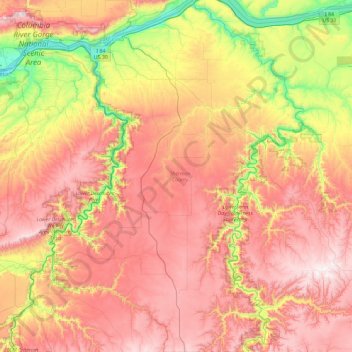
Name: Sherman County topographic map, elevation, terrain.

Location: Sherman County, Oregon, United States (45.08295 -121.03074 45.73725 -120.35769)

Average elevation: 534 m

Minimum elevation: 21 m

Maximum elevation: 1,019 m

Other topographic maps

Click on a map to view its topography, its elevation and its terrain.

Moccasin Lake

United States > Oregon > Wallowa County

Average elevation: 2,367 m

Harris

United States > Oregon > Benton County

Average elevation: 257 m

Selma

United States > Oregon > Josephine County

Average elevation: 438 m

The Cascades

United States > Oregon > Klamath County

Average elevation: 1,589 m

Mount Hood

United States > Oregon > Hood River County

Timberline Lodge is a National Historic Landmark located on the southern flank of Mount Hood just below Palmer Glacier, with an elevation of about 6,000 ft (1,800 m).

Average elevation: 2,716 m

Sand Hills

United States > Oregon > Malheur County

Average elevation: 1,150 m

Hauser

United States > Oregon > Coos County

Average elevation: 26 m

Charleston

United States > Oregon > Coos County

Average elevation: 24 m

Boring

United States > Oregon > Clackamas County

Boring's landscape is hilly, with its elevation ranging between 548 feet (167 m) and 755 feet (230 m). Several creeks run west through the community limits into the Clackamas River, including Doane Creek, North Fork Deep Creek, and Tickle Creek.

Average elevation: 183 m

Stump Lake

United States > Oregon > Douglas County

Average elevation: 1,234 m

Yankton

United States > Oregon > Columbia County

Average elevation: 111 m

Three Sisters

United States > Oregon > Deschutes County

The Three Sisters are closely spaced volcanic peaks in the U.S. state of Oregon. They are part of the Cascade Volcanic Arc, a segment of the Cascade Range in western North America extending from southern British Columbia through Washington and Oregon to Northern California. Each more than 10,000 feet (3,000 m)…

Average elevation: 2,526 m

Alsea

United States > Oregon > Benton County

Average elevation: 154 m

Astoria

United States > Oregon > Clatsop County > Astoria

Average elevation: 17 m

Lewis Glacier

United States > Oregon > Deschutes County

Average elevation: 2,604 m

Mount Mazama

United States > Oregon

Mount Mazama (Giiwas in the Native American language Klamath) is a complex volcano in the state of Oregon, United States, in a segment of the Cascade Volcanic Arc and Cascade Range. Most of the mountain collapsed following a major eruption approximately 7,700 years ago. The volcano is in Klamath County, in the…

Average elevation: 1,880 m

Toms Lake

United States > Oregon

Average elevation: 1,543 m

Ibex Butte

United States > Oregon > Crook County

Average elevation: 1,360 m

Traverse Lake

United States > Oregon > Union County

Average elevation: 2,385 m

Elk Mountain

United States > Oregon > Hood River County

Average elevation: 1,456 m

Sunriver

United States > Oregon > Deschutes County

Average elevation: 1,312 m

Flynn

United States > Oregon > Benton County

Average elevation: 124 m

Gear up for your next adventure:

💧Filtered Water Bottle - Safe drinking water on the go
🧼Travel Hand Sanitizer - Keep hands clean when water is scarce
🥾Hiking Gaiters - Protect legs and shoes from mud, snow, and debris
🧼Biodegradable Camp Soap - Environmentally friendly cleaning for gear and body
🥾Waterproof Hiking Boots - Boots keeping your feet dry in wet conditions

As an Amazon Associate, this site earns from qualifying purchases at no extra cost to you.