Geolocate

Hauser topographic map

Click on the map to display elevation.

About this map

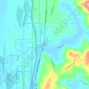
Name: Hauser topographic map, elevation, terrain.

Location: Hauser, Coos County, Oregon, 97459, United States (43.47289 -124.23873 43.51289 -124.19873)

Average elevation: 26 m

Minimum elevation: -1 m

Maximum elevation: 152 m

Other topographic maps

Click on a map to view its topography, its elevation and its terrain.

North Bend

United States > Oregon > Coos County

Average elevation: 11 m

Bunker Hill

United States > Oregon > Coos County

Average elevation: 20 m

Bandon

United States > Oregon > Coos County

Average elevation: 22 m

Gear up for your next adventure:

🧰Emergency Multi-Tool - Compact multi-tool for outdoor survival
🥾Durable Hiking Shoes - Long-lasting shoes for frequent hiking
🥾Mountaineering Boots - Supportive boots for climbing and high-altitude hiking
🔦UV Flashlight - Detect minerals or specific insects in the dark
💡LED Camping Lantern - Illuminate your campsite with long-lasting lanterns

As an Amazon Associate, this site earns from qualifying purchases at no extra cost to you.