Geolocate

Yankton topographic map

Click on the map to display elevation.

About this map

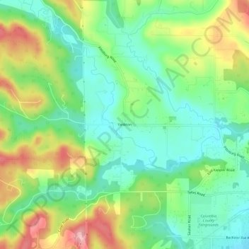
Name: Yankton topographic map, elevation, terrain.

Location: Yankton, Columbia County, Oregon, United States (45.84629 -122.90732 45.88629 -122.86732)

Average elevation: 111 m

Minimum elevation: 57 m

Maximum elevation: 203 m

Gear up for your next adventure:

🧦Merino Wool Socks - Moisture-wicking comfort for long-distance hiking
🎒Fully Waterproof Backpack - Total protection for photography gear and electronics
🪑Ultralight Camping Stool - Compact seating for rest stops during long hikes
🥾Waterproof Hiking Boots - Boots keeping your feet dry in wet conditions
🧢Hiking Sun Hat - Wide-brimmed protection for exposed mountain ridges

As an Amazon Associate, this site earns from qualifying purchases at no extra cost to you.