
Make a donation
Gear up for your next adventure:
As an Amazon Associate, this site earns from qualifying purchases at no extra cost to you.
Lewis Glacier topographic map
Click on the map to display elevation.
Make a donation
Gear up for your next adventure:
As an Amazon Associate, this site earns from qualifying purchases at no extra cost to you.
About this map
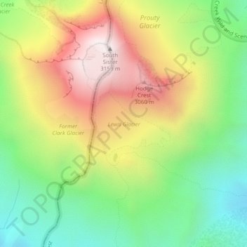
Name: Lewis Glacier topographic map, elevation, terrain.
Location: Lewis Glacier, Deschutes County, Oregon, United States (44.09190 -121.77167 44.09877 -121.76024)
Average elevation: 2,604 m
Minimum elevation: 2,177 m
Maximum elevation: 3,139 m
Make a donation
Gear up for your next adventure:
As an Amazon Associate, this site earns from qualifying purchases at no extra cost to you.
Other topographic maps
Click on a map to view its topography, its elevation and its terrain.
Three Sisters
United States > Oregon > Deschutes County
The Three Sisters are closely spaced volcanic peaks in the U.S. state of Oregon. They are part of the Cascade Volcanic Arc, a segment of the Cascade Range in western North America extending from southern British Columbia through Washington and Oregon to Northern California. Each more than 10,000 feet (3,000 m)…
Average elevation: 2,526 m