Geolocate

Mount Hood topographic map

Click on the map to display elevation.

Mount Hood

Timberline Lodge is a National Historic Landmark located on the southern flank of Mount Hood just below Palmer Glacier, with an elevation of about 6,000 ft (1,800 m).

Wikipedia (CC-BY-SA 3.0)

About this map

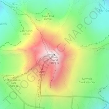
Name: Mount Hood topographic map, elevation, terrain.

Location: Mount Hood, Hood River County, Oregon, United States (45.37346 -121.69593 45.37356 -121.69583)

Average elevation: 2,716 m

Minimum elevation: 2,213 m

Maximum elevation: 3,416 m

Gear up for your next adventure:

🧤Thermal Hiking Gloves - Grip-enhanced gloves for cold-weather altitude trekking
🧤Rechargeable Heated Gloves - Extreme warmth for Canadian winter expeditions
🥾Mountaineering Boots - Supportive boots for climbing and high-altitude hiking
🛏️Camping Sleeping Mat - Comfortable mats for sleeping outdoors
🔭Compact Monocular - One-handed bird watching and trail spotting

As an Amazon Associate, this site earns from qualifying purchases at no extra cost to you.