
Three Sisters topographic map
Click on the map to display elevation.
Three Sisters
The Three Sisters are closely spaced volcanic peaks in the U.S. state of Oregon. They are part of the Cascade Volcanic Arc, a segment of the Cascade Range in western North America extending from southern British Columbia through Washington and Oregon to Northern California. Each more than 10,000 feet (3,000 m) in elevation, they are the third-, fourth- and fifth-highest peaks in Oregon. Located in the Three Sisters Wilderness at the boundary of Lane and Deschutes counties and the Willamette and Deschutes national forests, they are about 10 miles (16 km) south of the nearest town, Sisters. Diverse species of flora and fauna inhabit the area, which is subject to frequent snowfall, occasional rain, and extreme temperature variation between seasons. The mountains, particularly South Sister, are popular destinations for climbing and scrambling.
About this map
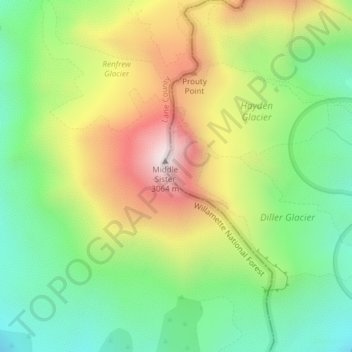
Name: Three Sisters topographic map, elevation, terrain.
Location: Three Sisters, Deschutes County, Oregon, United States (44.14716 -121.78299 44.14726 -121.78289)
Average elevation: 2,526 m
Minimum elevation: 2,164 m
Maximum elevation: 3,046 m
Other topographic maps
Click on a map to view its topography, its elevation and its terrain.