Geolocate

Porter topographic map

Click on the map to display elevation.

About this map

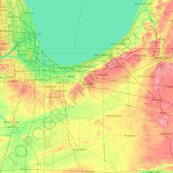
Name: Porter topographic map, elevation, terrain.

Location: Porter, Indiana, 46385, United States (40.74570 -87.77250 42.14570 -86.37250)

Average elevation: 207 m

Minimum elevation: 171 m

Maximum elevation: 286 m

Other topographic maps

Click on a map to view its topography, its elevation and its terrain.

Marion County

United States > Indiana

Average elevation: 241 m

Crothersville

United States > Indiana > Jackson County

Average elevation: 170 m

Danville

United States > Indiana > Hendricks County

Average elevation: 281 m

Porter County

United States > Indiana

Average elevation: 207 m

Newton County

United States > Indiana

Average elevation: 205 m

Jasper County

United States > Indiana

Average elevation: 208 m

LaGrange County

United States > Indiana

Average elevation: 279 m

Martin County

United States > Indiana

Average elevation: 180 m

Owen County

United States > Indiana

Average elevation: 206 m

DeKalb County

United States > Indiana

Average elevation: 272 m

St. Joseph

United States > Indiana

Average elevation: 252 m

Sugar Creek

United States > Indiana

Average elevation: 223 m

Ohio County

United States > Indiana

Average elevation: 223 m

White County

United States > Indiana

Average elevation: 210 m

Miami County

United States > Indiana

Average elevation: 237 m

Carroll County

United States > Indiana

Average elevation: 210 m

Daviess County

United States > Indiana

The terrain of Daviess County is hilly, with its area completely devoted to agriculture or urban development. Its highest elevation (740'/266 meters ASL) is a rise one mile (1.6 km) NNE of Farlen. The county is drained by the White River flowing to the southwest, whose two main forks (East White and West…

Average elevation: 154 m

Pike County

United States > Indiana

Average elevation: 146 m

Osgood

United States > Indiana > Ripley County

Average elevation: 300 m

Lake Monroe

United States > Indiana > Monroe County

Monroe Lake is a reservoir located about 10 miles (16 km) southeast of Bloomington, Indiana, United States. The lake is the largest entirely situated in Indiana with 10,750 acres (43.5 km2) of water surface area spread over the counties of Monroe and Brown. Capacity varies from 292 gigalitres (237,000…

Average elevation: 205 m

Logansport

United States > Indiana > Cass County

Average elevation: 203 m

Chalmers

United States > Indiana > White County

Average elevation: 214 m

Reynolds

United States > Indiana > White County

Average elevation: 211 m

Rocky Fork Lake

United States > Indiana > Parke County

Average elevation: 222 m

Clear Creek

United States > Indiana > Monroe County > Clear Creek

Average elevation: 218 m

Montezuma

United States > Indiana > Parke County

Average elevation: 153 m

Clear Lake

United States > Indiana > Steuben County

Average elevation: 321 m

Kendallville

United States > Indiana > Noble County

Average elevation: 303 m

Lowell

United States > Indiana > Lake County

Average elevation: 214 m

Avilla

United States > Indiana > Noble County

Average elevation: 294 m

Economy

United States > Indiana > Wayne County

Average elevation: 345 m

Brookston

United States > Indiana > White County

Average elevation: 208 m

Frankton

United States > Indiana > Madison County

Average elevation: 259 m

Pierceton

United States > Indiana > Kosciusko County

Average elevation: 280 m

North Judson

United States > Indiana > Starke County

Average elevation: 215 m

Farmland

United States > Indiana > Randolph County

Average elevation: 318 m

Edgewood

United States > Indiana > Madison County

Average elevation: 267 m

Mulberry

United States > Indiana > Clinton County

Average elevation: 237 m

Oak Park

United States > Indiana > Clark County

Average elevation: 140 m

Burns Harbor

United States > Indiana > Porter County

Average elevation: 189 m

Cambridge City

United States > Indiana > Wayne County

Average elevation: 292 m

Bremen

United States > Indiana > Marshall County

Bremen is located in northeastern Marshall County at 41°26′50″N 86°08′58″W / 41.447109°N 86.149342°W / 41.447109; -86.149342. It is at an elevation of 854 feet (260 m).

Average elevation: 252 m

Sweetser

United States > Indiana > Grant County

Average elevation: 257 m

North Salem

United States > Indiana > Hendricks County

Average elevation: 278 m

Lynn

United States > Indiana > Randolph County

Average elevation: 356 m

Arcadia

United States > Indiana > Hamilton County

Average elevation: 262 m

Worthington

United States > Indiana > Greene County

Average elevation: 162 m

Butler

United States > Indiana > DeKalb County

Average elevation: 265 m

Dale

United States > Indiana > Spencer County

Average elevation: 138 m

Greentown

United States > Indiana > Howard County

Average elevation: 258 m

Grand Calumet River

United States > Indiana > Lake County > Gary

Average elevation: 180 m

New Washington

United States > Indiana > Clark County

Average elevation: 214 m

Chandler

United States > Indiana > Warrick County

Average elevation: 129 m

Yorktown

United States > Indiana > Delaware County

Average elevation: 282 m

Eaton

United States > Indiana > Delaware County

Average elevation: 279 m

Albany

United States > Indiana > Delaware County

Average elevation: 290 m

Chesterfield

United States > Indiana > Madison County

Average elevation: 277 m

Hamilton

United States > Indiana > Steuben County

Average elevation: 283 m

Corunna

United States > Indiana > DeKalb County

Average elevation: 295 m

Altona

United States > Indiana > DeKalb County

Average elevation: 271 m

Lake Santee

United States > Indiana > Decatur County

Average elevation: 307 m

St. Paul

United States > Indiana > Decatur County

Average elevation: 258 m

Westport

United States > Indiana > Decatur County

Average elevation: 249 m

Millhousen

United States > Indiana > Decatur County

Average elevation: 277 m

New Point

United States > Indiana > Decatur County

Average elevation: 301 m

Hidden Valley

United States > Indiana > Dearborn County

Average elevation: 214 m

Saint Leon

United States > Indiana > Dearborn County

Average elevation: 288 m

Dillsboro

United States > Indiana > Dearborn County

Average elevation: 260 m

Greendale

United States > Indiana > Dearborn County

Average elevation: 168 m

Boston

United States > Indiana > Wayne County

Average elevation: 344 m

Haw Creek

United States > Indiana > Bartholomew County > Hope

Average elevation: 209 m

Oldenburg

United States > Indiana > Franklin County

Average elevation: 288 m

Mount Carmel

United States > Indiana > Franklin County

Average elevation: 307 m

Galena

United States > Indiana > Floyd County

Average elevation: 232 m

Greenville

United States > Indiana > Floyd County

Average elevation: 245 m

Georgetown

United States > Indiana > Floyd County

Average elevation: 248 m

Glenwood

United States > Indiana > Rush County

Average elevation: 332 m

Parker City

United States > Indiana > Randolph County

According to the 2010 census, Parker City has a total area of 0.57 square miles (1.48 km2), all land. It is located at an elevation of 1025 feet.

Average elevation: 312 m

Wabash

United States > Indiana > Wabash County

Average elevation: 233 m

Milford

United States > Indiana > Kosciusko County

Average elevation: 255 m

Kentland

United States > Indiana > Newton County

Average elevation: 207 m

Haubstadt

United States > Indiana > Gibson County

Average elevation: 141 m

Jonesboro

United States > Indiana > Grant County

Average elevation: 260 m

Argos

United States > Indiana > Marshall County

Average elevation: 251 m

Meridian Hills

United States > Indiana > Marion County

Average elevation: 237 m

Churubusco

United States > Indiana > Whitley County

Average elevation: 274 m

Lanesville

United States > Indiana > Harrison County

Average elevation: 239 m

New Amsterdam

United States > Indiana > Harrison County

Average elevation: 151 m

New Middletown

United States > Indiana > Harrison County

Average elevation: 215 m

Wilkinson

United States > Indiana > Hancock County

Average elevation: 307 m

Spring Lake

United States > Indiana > Hancock County

Average elevation: 259 m

New Palestine

United States > Indiana > Hancock County

Average elevation: 253 m

Cumberland

United States > Indiana > Hancock County

Average elevation: 261 m

Stilesville

United States > Indiana > Hendricks County

Average elevation: 240 m

Gear up for your next adventure:

Backpacking Tent - Lightweight tent for long-distance hiking trips
🧭GPS Handheld Device - Reliable GPS navigation for outdoor adventures
🗺️Topographic Maps - Detailed maps to explore trails, mountains, and wilderness areas
🔥Camping Stove - Portable stoves to cook outdoors with ease
🥾Hiking Gaiters - Protect legs and shoes from mud, snow, and debris

As an Amazon Associate, this site earns from qualifying purchases at no extra cost to you.