Geolocate

Alexandria topographic map

Click on the map to display elevation.

About this map

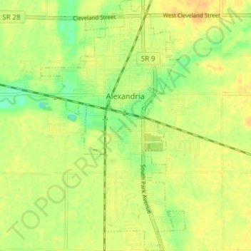
Name: Alexandria topographic map, elevation, terrain.

Location: Alexandria, Madison County, Indiana, 46001, United States (40.23399 -85.69636 40.28065 -85.66118)

Average elevation: 268 m

Minimum elevation: 251 m

Maximum elevation: 278 m

Other topographic maps

Click on a map to view its topography, its elevation and its terrain.

Meadowbrook

United States > Indiana > Madison County > Anderson

Average elevation: 273 m

Florida

United States > Indiana > Madison County > Florida

Average elevation: 269 m

Gear up for your next adventure:

🧼Travel Hand Sanitizer - Keep hands clean when water is scarce
💧Hydration Bladder - Hands-free hydration solution for long treks
🥾Hiking Shoes - Durable and comfortable shoes for trail hiking
🧴Sunscreen SPF - Broad-spectrum sunscreen for outdoor activities
🦟Insect Repellent - Keep mosquitoes and black flies away in wooded areas

As an Amazon Associate, this site earns from qualifying purchases at no extra cost to you.