
Avilla topographic map
Click on the map to display elevation.
About this map
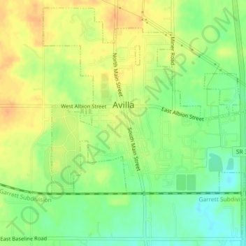
Name: Avilla topographic map, elevation, terrain.
Location: Avilla, Noble County, Indiana, United States (41.35116 -85.25061 41.37653 -85.21778)
Average elevation: 294 m
Minimum elevation: 275 m
Maximum elevation: 309 m
Other topographic maps
Click on a map to view its topography, its elevation and its terrain.
Kendallville
United States > Indiana > Noble County > Kendallville > Kendallville
Average elevation: 304 m