Geolocate

Pierceton topographic map

Click on the map to display elevation.

About this map

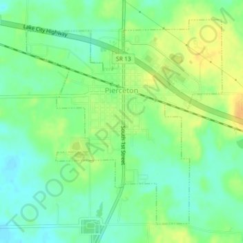
Name: Pierceton topographic map, elevation, terrain.

Location: Pierceton, Kosciusko County, Indiana, United States (41.18547 -85.71962 41.20818 -85.69069)

Average elevation: 280 m

Minimum elevation: 266 m

Maximum elevation: 296 m

Other topographic maps

Click on a map to view its topography, its elevation and its terrain.

Warsaw

United States > Indiana > Kosciusko County > Warsaw > Warsaw

Average elevation: 255 m

Atwood

United States > Indiana > Kosciusko County

Average elevation: 246 m

Gear up for your next adventure:

🏃Hydration Running Vest - Carry water and maps close to your body for speed
🛶Kayak Dry Bag - Waterproof storage for kayaking adventures
🎒Fully Waterproof Backpack - Total protection for photography gear and electronics
🧼Travel Hand Sanitizer - Keep hands clean when water is scarce
🎒Backpack Rain Cover - External shield to keep your entire pack dry

As an Amazon Associate, this site earns from qualifying purchases at no extra cost to you.