Geolocate

Eaton topographic map

Click on the map to display elevation.

About this map

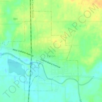
Name: Eaton topographic map, elevation, terrain.

Location: Eaton, Delaware County, Indiana, 47338, United States (40.33110 -85.37232 40.35220 -85.34136)

Average elevation: 279 m

Minimum elevation: 267 m

Maximum elevation: 295 m

Other topographic maps

Click on a map to view its topography, its elevation and its terrain.

Andersonville

United States > Indiana > Delaware County > Muncie

Average elevation: 287 m

Cowan

United States > Indiana > Delaware County

Average elevation: 303 m

Oakville

United States > Indiana > Delaware County

Average elevation: 309 m

Royerton

United States > Indiana > Delaware County

Average elevation: 285 m

White River

United States > Indiana > Delaware County > Yorktown

Average elevation: 282 m

Creston

United States > Indiana > Delaware County > Muncie > Creston

Average elevation: 292 m

Muncie

United States > Indiana > Delaware County > Muncie

Average elevation: 294 m

Gear up for your next adventure:

🥾Trail Hiking Socks - Comfortable socks to prevent blisters and fatigue
🧭GPS Tracker - Track your location in remote areas safely
🦯Trekking Poles - Reduced impact on joints for steep topographic climbs
🛏️Camping Sleeping Mat - Comfortable mats for sleeping outdoors
💧Hydration Pack - Hands-free hydration system for long hikes

As an Amazon Associate, this site earns from qualifying purchases at no extra cost to you.