
Lecco topographic map
Click on the map to display elevation.
About this map
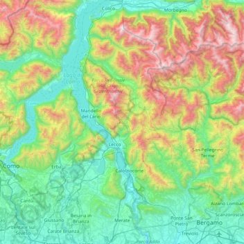
Name: Lecco topographic map, elevation, terrain.
Location: Lecco, Lombardy, Italy (45.64938 9.24373 46.15172 9.54111)
Average elevation: 797 m
Minimum elevation: 153 m
Maximum elevation: 2,550 m
Other topographic maps
Click on a map to view its topography, its elevation and its terrain.
Pianca
Italy > Lombardy > Varese > Maccagno con Pino e Veddasca > Maccagno Superiore
Average elevation: 364 m
Pianca
Italy > Lombardy > Varese > Maccagno con Pino e Veddasca > Maccagno Superiore
Average elevation: 364 m
Parco archeologico di Castel Seprio
Italy > Lombardy > Varese > Castelseprio > Vico Seprio
Average elevation: 314 m
Monte Bregagno
Italy > Lombardy > Como > Cremia
Monte Bregagno is a mountain of Lombardy, Italy, It has an elevation of 2,107 metres.
Average elevation: 1,688 m
Forte di Pietole
Italy > Lombardy > Mantua > Borgo Virgilio > Pietole > Pietole Vecchia
Average elevation: 19 m