Geolocate

Ospiate topographic map

Click on the map to display elevation.

About this map

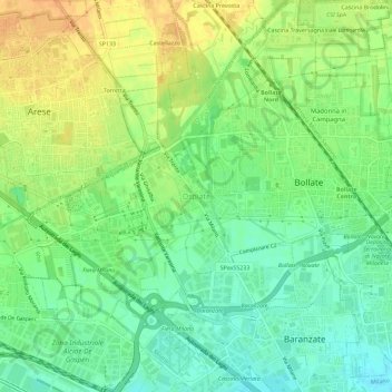
Name: Ospiate topographic map, elevation, terrain.

Location: Ospiate, Bollate, Milan, Lombardy, 20021, Italy (45.52129 9.08116 45.56129 9.12116)

Average elevation: 156 m

Minimum elevation: 140 m

Maximum elevation: 173 m

Gear up for your next adventure:

🗺️Topographic Maps - Detailed maps to explore trails, mountains, and wilderness areas
🔭Compact Monocular - One-handed bird watching and trail spotting
🔦LED Headtorch - Bright and durable light for night activities
🥾Trail Hiking Boots - Supportive boots for rough trails
💡Compact LED Flashlight - Powerful and portable flashlight for outdoor use

As an Amazon Associate, this site earns from qualifying purchases at no extra cost to you.