Geolocate

Cegni topographic map

Click on the map to display elevation.

About this map

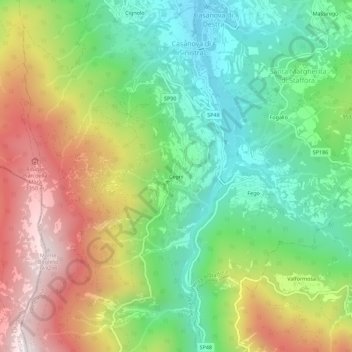
Name: Cegni topographic map, elevation, terrain.

Location: Cegni, Santa Margherita di Staffora, Pavia, Lombardy, Italy (44.73337 9.21510 44.77337 9.25510)

Average elevation: 927 m

Minimum elevation: 540 m

Maximum elevation: 1,495 m

Gear up for your next adventure:

👟Sport Hiking Sandals - Breathable footwear for water crossings and camp rest
🏃Hydration Running Vest - Carry water and maps close to your body for speed
🏕️Camping Hammock - Integrated protection for sleeping between trees
🧦Thermal Socks - Warm socks for winter hiking or camping
🧴Bear Spray Holster - Quick-access carry for essential Canadian wilderness safety

As an Amazon Associate, this site earns from qualifying purchases at no extra cost to you.