Geolocate

Bindella topographic map

Click on the map to display elevation.

About this map

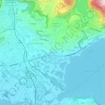
Name: Bindella topographic map, elevation, terrain.

Location: Bindella, Erba, Como, Lombardy, 22046, Italy (45.78860 9.22822 45.82860 9.26822)

Average elevation: 311 m

Minimum elevation: 254 m

Maximum elevation: 666 m

Gear up for your next adventure:

🥾Trail Hiking Shoes - Durable shoes designed for rugged trails
🩹Moleskin Blister Pads - Direct protection for painful foot pressure points
🩹Compact First Aid Kit - Pre-packed essentials for common trail injuries
🦯Trekking Poles - Reduced impact on joints for steep topographic climbs
🧥Ultralight Puffy Jacket - Maximum warmth that packs down to the size of an orange

As an Amazon Associate, this site earns from qualifying purchases at no extra cost to you.