
Clark County topographic map
Interactive map
Click on the map to display elevation.
About this map
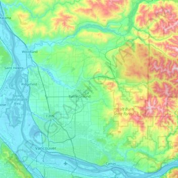
Name: Clark County topographic map, elevation, terrain.
Location: Clark County, Washington, United States (45.54373 -122.79596 46.05972 -122.24453)
Average elevation: 266 m
Minimum elevation: -3 m
Maximum elevation: 1,318 m
Many lakes border the river in the lowlands near Ridgefield, including Vancouver Lake. Eastern and northern Clark County contain forested foothills of the Cascade Mountains, rising to an elevation of 4,000 feet (1,200 m) on the border with Skamania County. Larch Mountain is the county's highest free-standing peak.
Other topographic maps
Click on a map to view its topography, its elevation and its terrain.
Bellevue
United States > Washington > King County
Bellevue, King County, Washington, United States
Average elevation: 66 m
Seattle
United States > Washington > King County
Seattle, King County, Washington, United States
Average elevation: 40 m
Point Roberts
United States > Washington > Whatcom County > Point Roberts
Point Roberts, Whatcom County, Washington, 98281, United States
Average elevation: 9 m
Tacoma
United States > Washington > Pierce County
Tacoma, Pierce County, Washington, United States
Average elevation: 67 m
Bothell
United States > Washington > King County
Bothell, King County, Washington, United States
Average elevation: 68 m
Kittitas County
Kittitas County, Washington, United States
Average elevation: 924 m
Allyn
United States > Washington > Mason County
Allyn, Mason County, Washington, 98524, United States
Average elevation: 45 m
Factoria
United States > Washington > King County > Bellevue
Factoria, Bellevue, King County, Washington, 98006, United States
Average elevation: 75 m
West Richland
United States > Washington > Benton County
West Richland, Benton County, Washington, 99353, United States
Average elevation: 146 m
Azure Lake
United States > Washington > King County
Azure Lake, King County, Washington, United States
Average elevation: 1,529 m
Juniper Beach
United States > Washington > Island County
Juniper Beach, Island County, Washington, United States
Average elevation: 9 m
Mercer Island
United States > Washington > Mercer Island
Mercer Island, King County, Washington, 98040, United States
Average elevation: 38 m
Sudden Valley
United States > Washington > Whatcom County
Sudden Valley, Whatcom County, Washington, United States
Average elevation: 239 m
Chain Lakes
United States > Washington > Chelan County
Chain Lakes, Chelan County, Washington, United States
Average elevation: 1,697 m
Pullman
United States > Washington > Whitman County
Pullman, Whitman County, Washington, United States
Average elevation: 774 m
Vail
United States > Washington > Thurston County
Vail, Thurston County, Washington, United States
Average elevation: 183 m
Rainier
United States > Washington > Thurston County
Rainier, Thurston County, Washington, 98576, United States
Average elevation: 143 m
Spanaway
United States > Washington > Pierce County
Spanaway, Pierce County, Washington, 98404, United States
Average elevation: 118 m
Moses Lake
United States > Washington > Grant County
Moses Lake, Grant County, Washington, 98837, United States
Average elevation: 350 m
Ocean Park
United States > Washington > Pacific County
Ocean Park, Pacific County, Washington, 98637, United States
Average elevation: 4 m
Sammamish
United States > Washington > King County
Sammamish, King County, Washington, United States
Average elevation: 97 m
Epperson Creek Fish Pond Dam
United States > Washington > Clallam County
Epperson Creek Fish Pond Dam, Clallam County, Washington, 98324, United States
Average elevation: 30 m
Ellensburg
United States > Washington > Kittitas County > Ellensburg > Ellensburg
Ellensburg, Kittitas County, Washington, 98926, United States
Average elevation: 485 m
Charlotte's Blueberry Park
United States > Washington > Pierce County > Tacoma
Charlotte's Blueberry Park, South End, Tacoma, Pierce County, Washington, United States
Average elevation: 121 m
Kalama
United States > Washington > Cowlitz County
Kalama, Cowlitz County, Washington, 98625, United States
Average elevation: 58 m
Maplewood
United States > Washington > King County > Renton
Maplewood, Renton, King County, Washington, 98058, United States
Average elevation: 102 m
Lake City Memorial Triangle
United States > Washington > King County > Seattle
Lake City Memorial Triangle, 12354, Lake City, Seattle, King County, Washington, 98125, United States
Average elevation: 61 m
Leavenworth
United States > Washington > Chelan County
Leavenworth, Chelan County, Washington, United States
Average elevation: 418 m
Cashmere
United States > Washington > Chelan County
Cashmere, Chelan County, Washington, United States
Average elevation: 298 m
Dee Lake
United States > Washington > Skamania County
Dee Lake, Skamania County, Washington, United States
Average elevation: 1,308 m
Burien
United States > Washington > King County
Burien, King County, Washington, United States
Average elevation: 65 m
Index
United States > Washington > Snohomish County
Index, Snohomish County, Washington, United States
Average elevation: 366 m
Orting
United States > Washington > Pierce County
Orting, Pierce County, Washington, 98360, United States
Average elevation: 112 m
Birch Bay
United States > Washington > Whatcom County
Birch Bay, Whatcom County, Washington, United States
Average elevation: 21 m
Steilacoom
United States > Washington > Pierce County
Steilacoom, Pierce County, Washington, 98388, United States
Average elevation: 37 m
Bainbridge Island
United States > Washington > Kitsap County
Bainbridge Island, Kitsap County, Washington, 98110, United States
Average elevation: 24 m
Tomtit Lake
United States > Washington > Snohomish County
Tomtit Lake, Snohomish County, Washington, United States
Average elevation: 272 m
Maple Falls
United States > Washington > Whatcom County
Maple Falls, Whatcom County, Washington, United States
Average elevation: 442 m
Dagger Lake
United States > Washington > Chelan County
Dagger Lake, Chelan County, Washington, United States
Average elevation: 1,845 m
Silver Star Mountain
United States > Washington > Skamania County
Silver Star Mountain, Skamania County, Washington, United States
Average elevation: 1,020 m
Colville
United States > Washington > Stevens County
Colville, Stevens County, Washington, United States
Average elevation: 559 m
La Conner
United States > Washington > Skagit County
La Conner, Skagit County, Washington, United States
Average elevation: 14 m
White Center
United States > Washington > King County
White Center, King County, Washington, 98146, United States
Average elevation: 58 m
Ferndale
United States > Washington > Whatcom County
Ferndale, Whatcom County, Washington, United States
Average elevation: 29 m
Chehalis
United States > Washington > Lewis County
Chehalis, Lewis County, Washington, United States, Stan Hedwall Park
Average elevation: 67 m
Carpenter Lake Nature Preserve
United States > Washington > Kitsap County > Kingston
Carpenter Lake Nature Preserve, Carpenter Lake Trail, Kingston, Kitsap County, Washington, 98346, United States
Average elevation: 36 m
Waterfront Park
United States > Washington > Clark County > Vancouver
Waterfront Park, The Waterfront, Esther Short, Vancouver, Clark County, Washington, United States
Average elevation: 13 m
Mead
United States > Washington > Spokane County
Mead, Spokane County, Washington, 99021, United States
Average elevation: 585 m
Kachess Lake
United States > Washington > Kittitas County
Kachess Lake, Kittitas County, Washington, United States
Average elevation: 1,090 m
Sequim
United States > Washington > Clallam County
Sequim, Clallam County, Washington, United States
Average elevation: 88 m