
Make a donation
Gear up for your next adventure:
As an Amazon Associate, this site earns from qualifying purchases at no extra cost to you.
Kalama topographic map
Click on the map to display elevation.
Make a donation
Gear up for your next adventure:
As an Amazon Associate, this site earns from qualifying purchases at no extra cost to you.
About this map
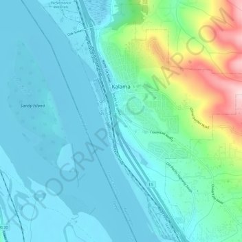
Name: Kalama topographic map, elevation, terrain.
Location: Kalama, Cowlitz County, Washington, United States (45.98303 -122.86131 46.02239 -122.80276)
Average elevation: 58 m
Minimum elevation: -2 m
Maximum elevation: 301 m
Make a donation
Gear up for your next adventure:
As an Amazon Associate, this site earns from qualifying purchases at no extra cost to you.
Other topographic maps
Click on a map to view its topography, its elevation and its terrain.
Toutle River Sediment Retention Structure
United States > Washington > Cowlitz County
Average elevation: 347 m
Make a donation
Gear up for your next adventure:
As an Amazon Associate, this site earns from qualifying purchases at no extra cost to you.
Toutle River Sediment Retention Structure
United States > Washington > Cowlitz County
Average elevation: 347 m