Geolocate

Kittitas County topographic map

Interactive map

Click on the map to display elevation.

About this map

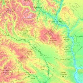
Name: Kittitas County topographic map, elevation, terrain.

Location: Kittitas County, Washington, United States (46.73647 -121.46603 47.59789 -119.92561)

Average elevation: 924 m

Minimum elevation: 139 m

Maximum elevation: 2,747 m

Other topographic maps

Click on a map to view its topography, its elevation and its terrain.

Bellevue

United States > Washington > King County

Average elevation: 66 m

Seattle

United States > Washington > King County

The city itself is hilly, though not uniformly so. Like Rome, the city is said to lie on seven hills; the lists vary but typically include Capitol Hill, First Hill, West Seattle, Beacon Hill, Queen Anne, Magnolia, and the former Denny Hill. The Wallingford, Delridge, Mount Baker, Seward Park, Washington Park,…

Average elevation: 40 m

Tacoma

United States > Washington > Pierce County

Tacoma is at 47°14′29″N 122°27′34″W / 47.24139°N 122.45944°W / 47.24139; -122.45944 (47.241371, −122.459389). Its official elevation is 381 feet (116 m), varying between sea level and about 500 feet (150 m).

Average elevation: 67 m

Bothell

United States > Washington > King County

Average elevation: 68 m

Barnaby Island

United States > Washington > Ferry County

Average elevation: 441 m

Kirkland

United States > Washington > King County

According to the United States Census Bureau, the city has a total area of 17.83 square miles (46.18 km2), of which 17.818 square miles (46.15 km2) are land and 0.012 square miles (0.03 km2) are water. The elevation varies from 14 to 500 feet (150 m) above sea level.

Average elevation: 55 m

Airway Heights

United States > Washington > Spokane County

The community lies in the northeastern corner of the flat Columbia Plateau. While the plateau tends to be flat, the terrain locally is quite rugged as it is part of the Channeled Scablands. The "heights" in the city's name references its location at a higher elevation than the city center of Spokane. Traveling…

Average elevation: 724 m

Pierce County

United States > Washington

Average elevation: 498 m

South Hill

United States > Washington > Pierce County

Average elevation: 140 m

Waller

United States > Washington > Pierce County > Tacoma

Average elevation: 59 m

Algona

United States > Washington > King County

Average elevation: 55 m

Duvall

United States > Washington > King County

Average elevation: 50 m

Mukilteo

United States > Washington > Snohomish County

Average elevation: 89 m

Rockport

United States > Washington > Skagit County > Rockport

Average elevation: 160 m

Concrete

United States > Washington > Skagit County

Mears Field (3W5), formerly known as Concrete Municipal Airport, is located one mile south of Concrete at an elevation of 267 ft MSL.

Average elevation: 125 m

Marblemount

United States > Washington > Skagit County

Average elevation: 249 m

Skagit County

United States > Washington

Average elevation: 753 m

Greenwater

United States > Washington > Pierce County

Greenwater is located at the confluence of the Greenwater and White Rivers, at an approximate elevation of 1,700 feet (520 m) above sea level.

Average elevation: 655 m

Okanogan County

United States > Washington

Average elevation: 1,094 m

Thurston County

United States > Washington

Average elevation: 150 m

Walla Walla County

United States > Washington

Average elevation: 369 m

Lipsy Lake

United States > Washington > King County

Average elevation: 825 m

William O. Douglas Wilderness

United States > Washington > Yakima County

While significant portions of the William O. Douglas Wilderness are high elevation forest, the overall topography is varied. The tallest and most visually striking peak is Mount Aix at 7,766 feet (2,367 m) with a prominence of 3,286 feet (1,002 m). The Cougar Lakes portion is characterized by high alpine…

Average elevation: 1,371 m

Kalama

United States > Washington > Cowlitz County

Average elevation: 58 m

Altoona

United States > Washington > Wahkiakum County

Average elevation: 66 m

Chelan County

United States > Washington

Average elevation: 1,094 m

Allyn

United States > Washington > Mason County

Average elevation: 45 m

Burien

United States > Washington > King County

Average elevation: 65 m

Factoria

United States > Washington > King County > Bellevue

Average elevation: 75 m

West Richland

United States > Washington > Benton County

The original people of the region were the Chemnapum Indians (closely related to the Wanapum tribe), living near the mouth of the Yakima River. Lewis and Clark passed through the area in 1805, and an expedition of the Army Corps of Topographical Engineers headed by Robert E Johnson mapped the Yakima Valley in…

Average elevation: 146 m

Azure Lake

United States > Washington > King County

Average elevation: 1,529 m

Chain Lakes

United States > Washington > Chelan County

Average elevation: 1,697 m

Vail

United States > Washington > Thurston County

Average elevation: 183 m