Geolocate

Allyn topographic map

Click on the map to display elevation.

About this map

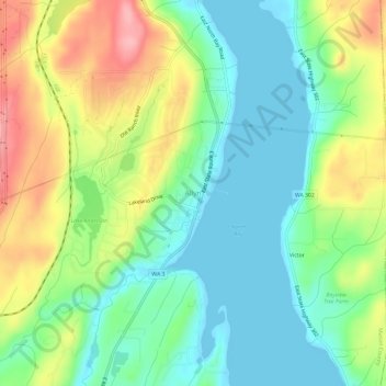
Name: Allyn topographic map, elevation, terrain.

Location: Allyn, Mason County, Washington, 98524, United States (47.36346 -122.85048 47.40346 -122.81048)

Average elevation: 45 m

Minimum elevation: -2 m

Maximum elevation: 125 m

Other topographic maps

Click on a map to view its topography, its elevation and its terrain.

Shelton

United States > Washington > Mason County

Average elevation: 54 m

Melbourne Lake

United States > Washington > Mason County

Average elevation: 255 m

Gear up for your next adventure:

🥾Trail Hiking Socks - Comfortable socks to prevent blisters and fatigue
🧭Orienteering Kit - Tools for map reading and navigation in the wild
🩹Moleskin Blister Pads - Direct protection for painful foot pressure points
🚲MTB Frame Bag - Carry tools and maps directly on your bicycle frame
🚲Handlebar Phone Mount - View topographic-map.com live while cycling

As an Amazon Associate, this site earns from qualifying purchases at no extra cost to you.