Geolocate

Vail topographic map

Click on the map to display elevation.

About this map

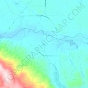
Name: Vail topographic map, elevation, terrain.

Location: Vail, Thurston County, Washington, United States (46.82510 -122.67623 46.86510 -122.63623)

Average elevation: 183 m

Minimum elevation: 106 m

Maximum elevation: 521 m

Gear up for your next adventure:

🔋Emergency Crank Radio - Weather alerts and power without needing batteries
🦶Anti-Blister Balm - Prevents friction and hotspots during long ascents
🥾Mountaineering Boots - Supportive boots for climbing and high-altitude hiking
🥾Light Trekking Boots - Supportive boots for multi-day treks
🔋Solar Power Bank - Keep your GPS and devices charged during long outdoor trips

As an Amazon Associate, this site earns from qualifying purchases at no extra cost to you.