Geolocate

White Center topographic map

Interactive map

Click on the map to display elevation.

About this map

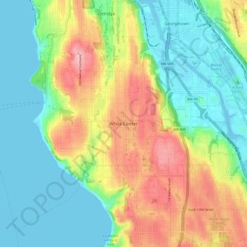
Name: White Center topographic map, elevation, terrain.

Location: White Center, King County, Washington, 98146, United States (47.47643 -122.39574 47.55643 -122.31574)

Average elevation: 58 m

Minimum elevation: -3 m

Maximum elevation: 160 m

Other topographic maps

Click on a map to view its topography, its elevation and its terrain.

Burien

United States > Washington > King County

Average elevation: 65 m

Chester Morse Lake

United States > Washington > King County

Chester Morse Lake (originally Cedar Lake) is a lake in the upper region of the Cedar River watershed in the U.S. state of Washington. The original lake surface was 1,530 feet (466 m) above sea level, but when the river was dammed in 1900, the elevation was raised to 1,560 feet (475 m). Chester Morse Lake is…

Average elevation: 735 m

Kirkland

United States > Washington > King County

According to the United States Census Bureau, the city has a total area of 17.83 square miles (46.18 km2), of which 17.818 square miles (46.15 km2) are land and 0.012 square miles (0.03 km2) are water. The elevation varies from 14 to 500 feet (150 m) above sea level.

Average elevation: 55 m

Federal Way

United States > Washington > King County

Average elevation: 81 m

Algona

United States > Washington > King County

Average elevation: 55 m

Duvall

United States > Washington > King County

Average elevation: 50 m

Lipsy Lake

United States > Washington > King County

Average elevation: 825 m

Azure Lake

United States > Washington > King County

Average elevation: 1,529 m

Sammamish

United States > Washington > King County

Average elevation: 97 m

Moira Lake

United States > Washington > King County

Average elevation: 1,303 m

Woodinville

United States > Washington > King County

Average elevation: 73 m

Annette Lake

United States > Washington > King County

Average elevation: 1,318 m

Shoreline

United States > Washington > King County

Average elevation: 99 m

Mercer Island

United States > Washington > King County > Mercer Island

Mercer Island City Hall is located at 47°34′39″N 122°12′43.2″W / 47.57750°N 122.212000°W / 47.57750; -122.212000 (47.5775, -122.212). The peak elevation in the city is about 338 feet (103 m), near the center of the island.

Average elevation: 39 m

Auburn

United States > Washington > King County

Average elevation: 88 m

Green Lake

United States > Washington > King County > Seattle

Average elevation: 75 m