
Make a donation
Gear up for your next adventure:
As an Amazon Associate, this site earns from qualifying purchases at no extra cost to you.
Kachess Lake topographic map
Click on the map to display elevation.
Make a donation
Gear up for your next adventure:
As an Amazon Associate, this site earns from qualifying purchases at no extra cost to you.
Kachess Lake
The lake is used as a storage reservoir for the Yakima Project, an irrigation project run by the United States Bureau of Reclamation. Although a natural lake, Kachess Lake's capacity and discharge is controlled by Kachess Dam, a 115-foot (35 m) high earthfill structure built in 1912. The discharge channel for Kachess Reservoir is 2,877 feet long and was constructed from the natural lake to the intake structure of the dam's outlet works, approximately 1800 feet downstream and at a lower elevation than the original lake outlet. The intent of the lowered outlet works was to put all of the average annual runoff into service by adding an additional 76,000 acre feet of natural lake water. As a storage reservoir, Kachess Lake's active capacity is 239,000 acre⋅ft (295 million m3).
Make a donation
Gear up for your next adventure:
As an Amazon Associate, this site earns from qualifying purchases at no extra cost to you.
About this map
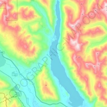
Name: Kachess Lake topographic map, elevation, terrain.
Location: Kachess Lake, Kittitas County, Washington, United States (47.26445 -121.25551 47.40491 -121.18733)
Average elevation: 1,090 m
Minimum elevation: 677 m
Maximum elevation: 1,770 m
Make a donation
Gear up for your next adventure:
As an Amazon Associate, this site earns from qualifying purchases at no extra cost to you.
Other topographic maps
Click on a map to view its topography, its elevation and its terrain.
Ellensburg
United States > Washington > Kittitas County > Ellensburg > Ellensburg
Average elevation: 485 m