
Make a donation
Gear up for your next adventure:
As an Amazon Associate, this site earns from qualifying purchases at no extra cost to you.
Simon Lake topographic map
Click on the map to display elevation.
Make a donation
Gear up for your next adventure:
As an Amazon Associate, this site earns from qualifying purchases at no extra cost to you.
About this map
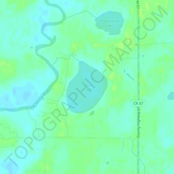
Name: Simon Lake topographic map, elevation, terrain.
Location: Simon Lake, Wadena County, Minnesota, United States (46.43036 -94.79518 46.43853 -94.78575)
Average elevation: 382 m
Minimum elevation: 377 m
Maximum elevation: 389 m
Make a donation
Gear up for your next adventure:
As an Amazon Associate, this site earns from qualifying purchases at no extra cost to you.
Other topographic maps
Click on a map to view its topography, its elevation and its terrain.
Make a donation
Gear up for your next adventure:
As an Amazon Associate, this site earns from qualifying purchases at no extra cost to you.
Make a donation
Gear up for your next adventure:
As an Amazon Associate, this site earns from qualifying purchases at no extra cost to you.
Make a donation
Gear up for your next adventure:
As an Amazon Associate, this site earns from qualifying purchases at no extra cost to you.
Wilmont
United States > Minnesota > Nobles County
According to the United States Census Bureau, the city has a total area of 1.14 square miles (2.95 km2), all land. By elevation, Wilmont is the highest incorporated community in Nobles County.
Average elevation: 527 m
Make a donation
Gear up for your next adventure:
As an Amazon Associate, this site earns from qualifying purchases at no extra cost to you.
Minneapolis
United States > Minnesota > Hennepin County > Minneapolis
A 1959 report by the U.S. Soil Conservation Service listed Minneapolis's elevation as 830 feet (250 m). The city's lowest elevation of 687 feet (209 m) above sea level is near where Minnehaha Creek meets the Mississippi River. Sources disagree on the exact location and elevation of the city's highest point,…
Average elevation: 271 m
Saint Paul
United States > Minnesota > Ramsey County
The year 1858 saw more than 1,000 steamboats service Saint Paul, making it a gateway for settlers to the Minnesota frontier or Dakota Territory. Geography was a primary reason the city became a transportation hub. The location was the last good point to land riverboats coming upriver due to the river valley's…
Average elevation: 268 m
Make a donation
Gear up for your next adventure:
As an Amazon Associate, this site earns from qualifying purchases at no extra cost to you.
Eagle Mountain
United States > Minnesota > Cook County
Eagle Mountain is only about 15 miles (24 km) from Minnesota's lowest elevation, Lake Superior, at 600 feet (183 m). It is part of the Canadian Shield. There is also another much shorter peak also named Eagle Mountain in northern Minnesota. The shorter peak is part of the Lutsen Mountains ski resort.
Average elevation: 596 m
Make a donation
Gear up for your next adventure:
As an Amazon Associate, this site earns from qualifying purchases at no extra cost to you.
Make a donation
Gear up for your next adventure:
As an Amazon Associate, this site earns from qualifying purchases at no extra cost to you.
North Shore Mining/Lake Superior Overlook
United States > Minnesota > Lake County > Silver Bay
Average elevation: 252 m
Make a donation
Gear up for your next adventure:
As an Amazon Associate, this site earns from qualifying purchases at no extra cost to you.
Make a donation
Gear up for your next adventure:
As an Amazon Associate, this site earns from qualifying purchases at no extra cost to you.
Make a donation
Gear up for your next adventure:
As an Amazon Associate, this site earns from qualifying purchases at no extra cost to you.
Swift County
Swift County is primarily agricultural, but also hosts agriculture equipment manufacturers and an ethanol plant. It has 24 lakes and nine rivers and streams. Lake Oliver is one of the county's biggest, at 416 acres (1.7 km2). Caltopo shows the true highpoint to be 1300 ft in elevation about 1/3 of a mile…
Average elevation: 332 m
Make a donation
Gear up for your next adventure:
As an Amazon Associate, this site earns from qualifying purchases at no extra cost to you.
Make a donation
Gear up for your next adventure:
As an Amazon Associate, this site earns from qualifying purchases at no extra cost to you.
Skyline
United States > Minnesota > Blue Earth County
According to the U.S. Census Bureau, the city has a total area of 0.17 square miles (0.44 km2), all land. Its elevation is 980 feet (300 m) above sea-level.
Average elevation: 265 m
Make a donation
Gear up for your next adventure:
As an Amazon Associate, this site earns from qualifying purchases at no extra cost to you.
Make a donation
Gear up for your next adventure:
As an Amazon Associate, this site earns from qualifying purchases at no extra cost to you.
Nobles County
Nobles County sits atop the Buffalo Ridge, a large expanse of rolling hills in southwestern Minnesota reaching a height of 1,995' (608m) ASL. The Buffalo Ridge marks the most southerly extent of the last glaciation, and extends 60 miles (96 km) through Lincoln, Lyon, Pipestone, Murray, Rock, and Nobles…
Average elevation: 487 m
Make a donation
Gear up for your next adventure:
As an Amazon Associate, this site earns from qualifying purchases at no extra cost to you.
Make a donation
Gear up for your next adventure:
As an Amazon Associate, this site earns from qualifying purchases at no extra cost to you.
Make a donation
Gear up for your next adventure:
As an Amazon Associate, this site earns from qualifying purchases at no extra cost to you.
Make a donation
Gear up for your next adventure:
As an Amazon Associate, this site earns from qualifying purchases at no extra cost to you.
Albert Lea
United States > Minnesota > Freeborn County
The city is named after Albert Miller Lea, a topographer with the United States Dragoons, who surveyed southern Minnesota and northern Iowa in 1835, including the current site of Albert Lea. Captain Nathan Boone, a son of Daniel Boone, was the scout for Lea's unit.
Average elevation: 382 m
Make a donation
Gear up for your next adventure:
As an Amazon Associate, this site earns from qualifying purchases at no extra cost to you.
Make a donation
Gear up for your next adventure:
As an Amazon Associate, this site earns from qualifying purchases at no extra cost to you.
Make a donation
Gear up for your next adventure:
As an Amazon Associate, this site earns from qualifying purchases at no extra cost to you.
Make a donation
Gear up for your next adventure:
As an Amazon Associate, this site earns from qualifying purchases at no extra cost to you.
Maple Lake
United States > Minnesota > Wright County > Maple Lake > Maple Lake
Average elevation: 314 m
Make a donation
Gear up for your next adventure:
As an Amazon Associate, this site earns from qualifying purchases at no extra cost to you.
Saint Louis Park
United States > Minnesota > Hennepin County > Saint Louis Park
Average elevation: 275 m
Make a donation
Gear up for your next adventure:
As an Amazon Associate, this site earns from qualifying purchases at no extra cost to you.
Fergus Falls
United States > Minnesota > Otter Tail County > Fergus Falls > Fergus Falls
Average elevation: 375 m
Make a donation
Gear up for your next adventure:
As an Amazon Associate, this site earns from qualifying purchases at no extra cost to you.