Geolocate

Moorhead topographic map

Click on the map to display elevation.

About this map

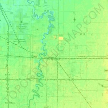
Name: Moorhead topographic map, elevation, terrain.

Location: Moorhead, Clay County, Minnesota, United States (46.81103 -96.80044 46.94860 -96.64777)

Average elevation: 277 m

Minimum elevation: 268 m

Maximum elevation: 285 m

Gear up for your next adventure:

🔪Outdoor Multitool - Versatile tool for repairs and food prep in the wild
👟Leg Gaiters - Keep debris, mud, and snow out of your boots
🥾Trail Running Boots - Durable shoes designed for trail running
🥘Camping Cookware Set - Compact nesting pots and pans for trail cooking
🛰️Satellite Messenger - Emergency communication for areas with no cell service

As an Amazon Associate, this site earns from qualifying purchases at no extra cost to you.