
Fairfax County topographic map
Interactive map
Click on the map to display elevation.
About this map
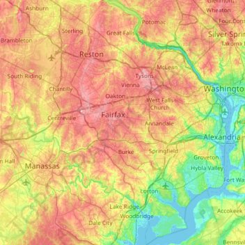
Name: Fairfax County topographic map, elevation, terrain.
Location: Fairfax County, Virginia, United States (38.60395 -77.53707 39.05771 -77.04055)
Average elevation: 75 m
Minimum elevation: -3 m
Maximum elevation: 168 m
Most of the county lies in the Piedmont region, with rolling hills and deep stream valleys such as Difficult Run and its tributaries. West of Route 28, the hills give way to a flat, gentle valley that stretches west to the Bull Run Mountains in Loudoun County. Elevations in the county range from near sea level along the tidal sections of the Potomac River in the southeast portion of the county to more than 500 feet (150 m) in the Tysons Corner area.
Other topographic maps
Click on a map to view its topography, its elevation and its terrain.
Amherst County
Amherst County, Virginia, United States
Average elevation: 329 m
Mechanicsville
United States > Virginia > Hanover County
Mechanicsville, Hanover County, Virginia, United States
Average elevation: 49 m
Eltham
United States > Virginia > New Kent County
Eltham, New Kent County, Virginia, 23181, United States
Average elevation: 3 m
Hawkins Lake
United States > Virginia > Culpeper County
Hawkins Lake, Culpeper County, Virginia, United States
Average elevation: 90 m
Hampton Roads
United States > Virginia > Newport News > Newport News
Hampton Roads, Newport News, Virginia, United States
Average elevation: 2 m
Albemarle County
Albemarle County, Virginia, United States
Average elevation: 258 m
Dinwiddie County
Dinwiddie County, Virginia, United States
Average elevation: 70 m
Jamestown
United States > Virginia > James City County
Jamestown, James City County, Virginia, 23081, United States
Average elevation: 1 m
Stafford County
Stafford County, Virginia, United States
Average elevation: 61 m
Madison County
Madison County, Virginia, United States
Average elevation: 305 m
Cumberland Gap
United States > Virginia > Lee County
Cumberland Gap, Lee County, Virginia, 37724, United States
Average elevation: 512 m
Keene Mill Manor
United States > Virginia > Fairfax County > West Springfield
Keene Mill Manor, West Springfield, Fairfax County, Virginia, 22152, United States
Average elevation: 81 m
Hog Island Wildlife Management Area - Carlisle Tract
United States > Virginia > Surry County
Hog Island Wildlife Management Area - Carlisle Tract, Lower Creek Drive, Surry County, Virginia, 23883, United States
Average elevation: 7 m
Triangle
United States > Virginia > Prince William County
Triangle, Prince William County, Virginia, 22172, United States
Average elevation: 43 m
Woodbridge
United States > Virginia > Prince William County
Woodbridge, Prince William County, Virginia, 22191, United States
Average elevation: 19 m
Lower Elk Creek
United States > Virginia > Grayson County
Lower Elk Creek, Grayson County, Virginia, 24326, United States
Average elevation: 808 m
Milton
United States > Virginia > Albemarle County
Milton, Albemarle County, Virginia, 22909, United States
Average elevation: 118 m
Newport
United States > Virginia > Augusta County
Newport, Augusta County, Virginia, 24459, United States
Average elevation: 564 m
East Pointe
United States > Virginia > Roanoke County
East Pointe, Roanoke County, Virginia, 24014, United States
Average elevation: 375 m
George Washington National Forest
United States > Virginia > Montebello
George Washington National Forest, FR 246, Montebello, Nelson County, Virginia, 24483, United States
Average elevation: 454 m
Blue Knob
United States > Virginia > Henry County
Blue Knob, Henry County, Virginia, United States
Average elevation: 363 m
Bluefield
United States > Virginia > Tazewell County
Bluefield, Tazewell County, Virginia, 24605, United States
Average elevation: 849 m
Brambleton
United States > Virginia > Loudoun County
Brambleton, Loudoun County, Virginia, 20107, United States
Average elevation: 99 m
Calmes Neck Estates
United States > Virginia > Clarke County
Calmes Neck Estates, Clarke County, Virginia, 22646, United States
Average elevation: 159 m
Sparkling Springs
United States > Virginia > Rockingham County
Sparkling Springs, Rockingham County, Virginia, 22850, United States
Average elevation: 554 m
Leesburg
United States > Virginia > Loudoun County
Leesburg, Loudoun County, Virginia, United States
Average elevation: 113 m
Berryville
United States > Virginia > Clarke County
Berryville, Clarke County, Virginia, 22611, United States
Average elevation: 182 m
Shenandoah County
Shenandoah County, Virginia, United States
Average elevation: 433 m
Big Hill
United States > Virginia > Rockbridge County
Big Hill, Rockbridge County, Virginia, 24415, United States
Average elevation: 466 m
Centreville
United States > Virginia > Fairfax County > Centreville
Centreville, Fairfax County, Virginia, United States
Average elevation: 92 m
Chantilly
United States > Virginia > Fairfax County > Chantilly
Chantilly, Fairfax County, Virginia, United States
Average elevation: 114 m
Petersburg
United States > Virginia > Petersburg
Petersburg, Virginia, 23804, United States
Average elevation: 42 m
Peales Crossroads
United States > Virginia > Rockingham County
Peales Crossroads, Rockingham County, Virginia, 22846, United States
Average elevation: 416 m
Earness
United States > Virginia > Poquoson
Earness, Poquoson, Virginia, 23662, United States
Average elevation: 1 m
Kenyon
United States > Virginia > Suffolk (city) > Suffolk
Kenyon, Suffolk, Suffolk (city), Virginia, United States
Average elevation: 19 m
Greenwood Farms
United States > Virginia > Hampton
Greenwood Farms, Hampton, Virginia, 23666, United States
Average elevation: 6 m
Front Royal
United States > Virginia > Warren County
Front Royal, Warren County, Virginia, United States
Average elevation: 194 m
Haysi
United States > Virginia > Dickenson County
Haysi, Dickenson County, Virginia, 24256, United States
Average elevation: 495 m
Kemp Woods Lake
United States > Virginia > Chesapeake
Kemp Woods Lake, Kemp Woods, Chesapeake, Virginia, United States
Average elevation: 8 m
Haymarket
United States > Virginia > Prince William County
Haymarket, Prince William County, Virginia, 20168, United States
Average elevation: 109 m
Indian
United States > Virginia > Tazewell County > Cedar Bluff
Indian, Cedar Bluff, Tazewell County, Virginia, 24609, United States
Average elevation: 681 m
Vaughn
United States > Virginia > Page County
Vaughn, Page County, Virginia, 22650, United States
Average elevation: 304 m
Blacksburg
United States > Virginia > Montgomery County
Blacksburg, Montgomery County, Virginia, United States
Average elevation: 621 m
Passage Creek
United States > Virginia > Shenandoah County > Detrick
Passage Creek, Detrick, Shenandoah County, Virginia, United States
Average elevation: 287 m
Buckingham County
Buckingham County, Virginia, United States
Average elevation: 156 m
Edinburg
United States > Virginia > Shenandoah County
Edinburg, Shenandoah County, Virginia, United States
Average elevation: 266 m