Geolocate

Edinburg topographic map

Click on the map to display elevation.

About this map

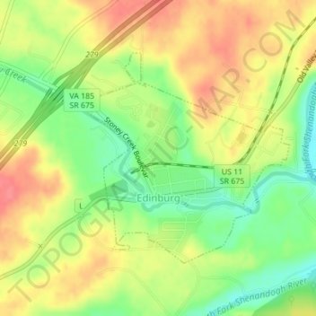
Name: Edinburg topographic map, elevation, terrain.

Location: Edinburg, Shenandoah County, Virginia, United States (38.81533 -78.57324 38.83331 -78.55147)

Average elevation: 266 m

Minimum elevation: 229 m

Maximum elevation: 298 m

Other topographic maps

Click on a map to view its topography, its elevation and its terrain.

Gear up for your next adventure:

🎒Hiking Backpack - Lightweight and ergonomic backpacks for day hikes or multi-day treks
🦶Anti-Blister Balm - Prevents friction and hotspots during long ascents
🔭Compact Monocular - One-handed bird watching and trail spotting
🛏️Camping Sleeping Mat - Comfortable mats for sleeping outdoors
🔭Outdoor Binoculars - Lightweight binoculars for birdwatching and hiking

As an Amazon Associate, this site earns from qualifying purchases at no extra cost to you.