

Leesburg topographic map
Click on the map to display elevation.
Leesburg
Leesburg is located northeast of the center of Loudoun County at 39°7′N 77°33′W / 39.117°N 77.550°W / 39.117; -77.550 (39.109, −77.558), It is part of the northern Virginia Piedmont and sits at the base of the easternmost chain of the Blue Ridge Mountains, Catoctin Mountain. The town lies in the Culpeper Basin (an inland sea during the Jurassic period) and is adjacent to the valley of the Potomac River, so that the local relief is less pronounced than in other Virginia Piedmont towns. Elevation in town ranges from about 350 to 400 feet (110 to 120 m), with the ridge of Catoctin Mountain rising to 670 feet (200 m) just west of the town limits. The Town Branch of Tuscarora Creek passes through the center of town, flowing east to Goose Creek, a tributary of the Potomac.
About this map
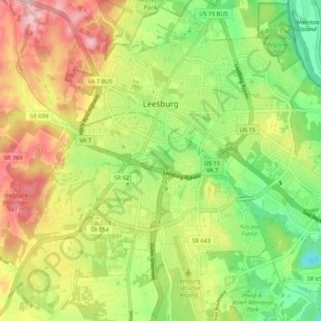
Name: Leesburg topographic map, elevation, terrain.
Location: Leesburg, Loudoun County, Virginia, United States (39.06762 -77.60243 39.13853 -77.50793)
Average elevation: 113 m
Minimum elevation: 32 m
Maximum elevation: 215 m
Other topographic maps
Click on a map to view its topography, its elevation and its terrain.
Lucketts Community Center
United States > Virginia > Loudoun County > Lucketts
Average elevation: 101 m