
Weinböhla topographic map
Click on the map to display elevation.
About this map
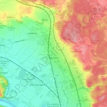
Name: Weinböhla topographic map, elevation, terrain.
Location: Weinböhla, Meißen, Sachsen, Deutschland (51.14312 13.53338 51.18598 13.63768)
Average elevation: 145 m
Minimum elevation: 94 m
Maximum elevation: 210 m
Other topographic maps
Click on a map to view its topography, its elevation and its terrain.
Nassau
Deutschland > Sachsen > Meißen > Meißen
Zentrum der Gemarkung ist die im Volksmund sogenannte Milchinsel, in früherer Zeit ein großer Gutshof. Nassau liegt auf einer Höhe von 107 m ü. NN im äußersten Nordwesten des Elbtalkessels. Die Elbe fließt drei Kilometer weiter südlich auf der anderen Seite des Spaargebirges. An den ÖPNV ist Nassau…
Average elevation: 125 m
Niederlommatzsch
Deutschland > Sachsen > Meißen > Diera-Zehren > Niederlommatzsch
Average elevation: 128 m
Lampersdorf
Deutschland > Sachsen > Meißen > Lampersdorf
Landwirtschaftlich genutzte Hochflächen umgeben das Dorf, in westlicher Richtung steigt das Gelände zur Baeyerhöhe hin an. Nach dieser Erhebung ist auch die Straße „Baeyerhöhe“ benannt, die den an der Westseite des Tals der Kleinen Triebisch gelegenen Ortskern des einseitigen Waldhufendorfs erschließt.
Average elevation: 269 m
Oberjahna
Deutschland > Sachsen > Meißen > Käbschütztal
Oberjahna befindet sich etwa vier Kilometer westlich der Kreisstadt Meißen auf etwa 200 Metern über Normalhöhennull. Östlich fließt der Jahnabach am Ort vorbei, der weiter nördlich bei Keilbusch (Gemeinde Diera-Zehren) in die Elbe mündet. Im Zentrum des Ortes befindet sich ein großer Dreiseithof, der…
Average elevation: 204 m
Albrechtsburg
Deutschland > Sachsen > Meißen > Meißen
Die Albrechtsburg auf dem Burgberg in Meißen ist eines der bekanntesten spätgotischen Architekturdenkmäler und gilt als der erste Schlossbau Deutschlands. Ab 1471 ließen die wettinischen Kurfürsten und Herzöge von Sachsen dort an der Stelle einer älteren mittelalterlichen Burg ein Residenzschloss…
Average elevation: 137 m
Schmiedewalde
Deutschland > Sachsen > Meißen
Durch Schmiedewalde fließt der Schmiedewalder Bach, ein von der Triebischseitentalbrücke überspannter rechter Zufluss der Triebisch. Südwestlich der Ortslage wurde Kalk abgebaut; als geflutetes Restloch erhalten blieb der Grüne See. Nordöstlich von Schmiedewalde befindet sich die Baeyerhöhe mit 320 m…
Average elevation: 273 m
Oberau
Deutschland > Sachsen > Meißen
Der Ortsname fand 1274 erstmals Erwähnung als „Owa“. Dieses mittelhochdeutsche Wort bedeutet „Aue“ und steht hier für Oberau und/oder Niederau. Schon zwei Jahre später nennt eine Urkunde den Personennamen „Ulricus de Ouwa“. Historiker nehmen deshalb an, dass 1276 ein Herrensitz im Ort bestand.…
Average elevation: 156 m
Baeyerhöhe
Deutschland > Sachsen > Meißen > Seeligstadt
Die Baeyerhöhe ist ein 320,5 m hoher Berg im Meißner Hochland. Die Baeyerhöhe ist der zweithöchste Berg des Landkreises Meißen in Sachsen.
Average elevation: 277 m
Hühndorf
Deutschland > Sachsen > Meißen > Klipphausen
Der Ortskern liegt am oberen Eingang zum engen Tal des Prinzbaches, der in seinem Hühndorfer Quellkessel eine flache Wiesenmulde bildet. Diese Reliefformen verhinderten die Anlage eines Reihendorfes; stattdessen entstand ein Platzdorf mit einer 229 Hektar großen, gelänge-waldhufenähnlichen Streifenflur.…
Average elevation: 267 m
Miltitz
Deutschland > Sachsen > Meißen
Der Ortskern mit seinen Vierseithöfen liegt entlang der Brauerei- und der Kirchstraße sowie an den Straßen „Am Rittergut“ und „Am Dorfberg“. Weitere benannte Straßen sind „Zum Pinzigberg“, „Lindenhöhe“, „Am Teichdamm“, Siedlerweg, Krögiser Straße und Lugaer Weg sowie die Talstraße,…
Average elevation: 228 m
Ziegenhain
Deutschland > Sachsen > Meißen > Nossen
Nossen wurde erstmals 1185 indirekt urkundlich als ein Herrensitz des Ritters Petrus de Nozin erwähnt. Er hatte das Land vom Bischof von Meißen zu Lehen. Unbekannt ist, ob die Ritter von Nozin damals auf dem Rodigt, einer slawischen Wallanlage auf einer Anhöhe in Nossen ihren Sitz hatten, oder sie bereits…
Average elevation: 199 m