
Make a donation
Gear up for your next adventure:
As an Amazon Associate, this site earns from qualifying purchases at no extra cost to you.
Karlshöhe topographic map
Click on the map to display elevation.
Make a donation
Gear up for your next adventure:
As an Amazon Associate, this site earns from qualifying purchases at no extra cost to you.
About this map
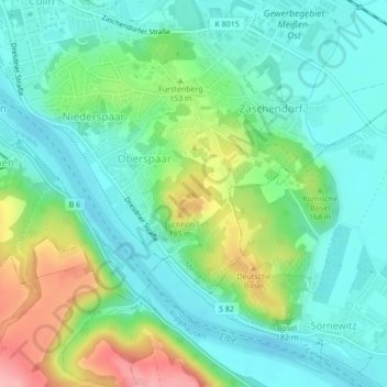
Name: Karlshöhe topographic map, elevation, terrain.
Location: Karlshöhe, Meißen, Sachsen, 01662, Deutschland (51.14676 13.50461 51.14686 13.50471)
Average elevation: 133 m
Minimum elevation: 94 m
Maximum elevation: 226 m
Make a donation
Gear up for your next adventure:
As an Amazon Associate, this site earns from qualifying purchases at no extra cost to you.
Other topographic maps
Click on a map to view its topography, its elevation and its terrain.
Albrechtsburg
Deutschland > Sachsen > Meißen > Meißen
Die Albrechtsburg auf dem Burgberg in Meißen ist eines der bekanntesten spätgotischen Architekturdenkmäler und gilt als der erste Schlossbau Deutschlands. Ab 1471 ließen die wettinischen Kurfürsten und Herzöge von Sachsen dort an der Stelle einer älteren mittelalterlichen Burg ein Residenzschloss…
Average elevation: 137 m