Geolocate

Planitz topographic map

Click on the map to display elevation.

About this map

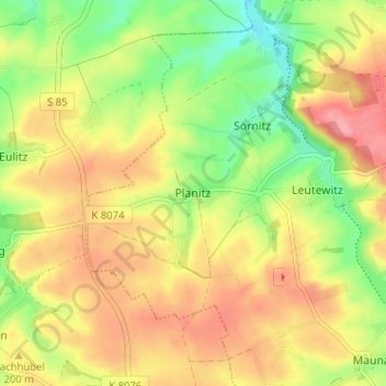
Name: Planitz topographic map, elevation, terrain.

Location: Planitz, Käbschütztal, Meißen, Sachsen, Deutschland (51.13049 13.32423 51.17049 13.36423)

Average elevation: 188 m

Minimum elevation: 137 m

Maximum elevation: 234 m

Gear up for your next adventure:

🐕Hiking Dog Pack - Let your canine companion carry their own water and food
🥾Waterproof Hiking Boots - Boots keeping your feet dry in wet conditions
🧥Ultralight Puffy Jacket - Maximum warmth that packs down to the size of an orange
🥫Freeze-Dried Meals - Lightweight, high-calorie nutrition for multi-day treks
🛁Quick-Dry Microfiber Towel - Space-saving towel that dries rapidly on the move

As an Amazon Associate, this site earns from qualifying purchases at no extra cost to you.