Geolocate

Stauda topographic map

Click on the map to display elevation.

About this map

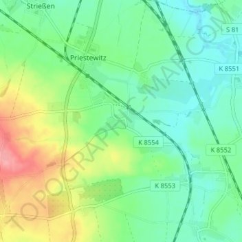
Name: Stauda topographic map, elevation, terrain.

Location: Stauda, Priestewitz, Meißen, Sachsen, 01558, Deutschland (51.22305 13.49807 51.26305 13.53807)

Average elevation: 152 m

Minimum elevation: 122 m

Maximum elevation: 216 m

Gear up for your next adventure:

🍽️Titanium Camping Spork - Ultralight and indestructible eating utensil
🧴Insect Repellent - Protect yourself from bugs during outdoor adventures
🔦LED Flashlight - Powerful and long-lasting flashlight for camping and emergencies
🧥Thermal Fleece Jacket - Versatile insulation for changing mountain temperatures
💧Hydration Pack - Hands-free hydration system for long hikes

As an Amazon Associate, this site earns from qualifying purchases at no extra cost to you.