Geolocate

Kaisitz topographic map

Click on the map to display elevation.

About this map

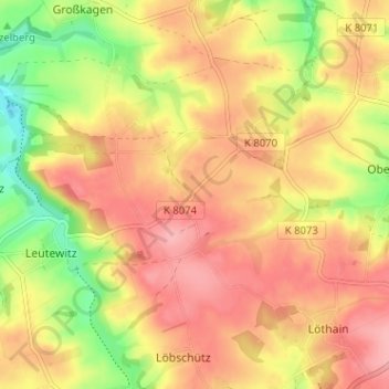
Name: Kaisitz topographic map, elevation, terrain.

Location: Kaisitz, Käbschütztal, Meißen, Sachsen, Deutschland (51.13678 13.36836 51.17678 13.40836)

Average elevation: 202 m

Minimum elevation: 139 m

Maximum elevation: 243 m

Gear up for your next adventure:

🧤Rechargeable Heated Gloves - Extreme warmth for Canadian winter expeditions
❄️Traction Ice Cleats - Slip-on spikes for icy trails and winter hiking
🧥Waterproof Pants - Keep dry during rainy hiking conditions
🧥Fleece Jacket - Warm and lightweight jacket for layering
🗺️Topographic Maps - Detailed maps to explore trails, mountains, and wilderness areas

As an Amazon Associate, this site earns from qualifying purchases at no extra cost to you.