
Make a donation
Gear up for your next adventure:
As an Amazon Associate, this site earns from qualifying purchases at no extra cost to you.
Lampersdorf topographic map
Click on the map to display elevation.
Make a donation
Gear up for your next adventure:
As an Amazon Associate, this site earns from qualifying purchases at no extra cost to you.
Lampersdorf
Landwirtschaftlich genutzte Hochflächen umgeben das Dorf, in westlicher Richtung steigt das Gelände zur Baeyerhöhe hin an. Nach dieser Erhebung ist auch die Straße „Baeyerhöhe“ benannt, die den an der Westseite des Tals der Kleinen Triebisch gelegenen Ortskern des einseitigen Waldhufendorfs erschließt.
Make a donation
Gear up for your next adventure:
As an Amazon Associate, this site earns from qualifying purchases at no extra cost to you.
About this map
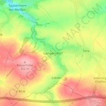
Name: Lampersdorf topographic map, elevation, terrain.
Location: Lampersdorf, Klipphausen, Meißen, Sachsen, Deutschland (51.05762 13.46328 51.09762 13.50328)
Average elevation: 269 m
Minimum elevation: 206 m
Maximum elevation: 321 m
Make a donation
Gear up for your next adventure:
As an Amazon Associate, this site earns from qualifying purchases at no extra cost to you.