
Java topographic map
Interactive map
Click on the map to display elevation.
About this map
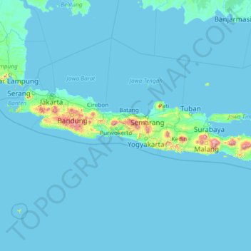
Name: Java topographic map, elevation, terrain.
Location: Java, Indonesia (-8.78042 105.20955 -5.87550 114.60539)
Average elevation: 41 m
Minimum elevation: -2 m
Maximum elevation: 3,329 m
Other topographic maps
Click on a map to view its topography, its elevation and its terrain.
Rantau Prapat
Indonesia > North Sumatra > Labuhanbatu
Rantau Prapat, Labuhanbatu, North Sumatra, Sumatra, 21411, Indonesia
Average elevation: 65 m
Tengah
Indonesia > Gorontalo > Gorontalo Utara
Tengah, Gorontalo Utara, Gorontalo, Sulawesi, Indonesia
Average elevation: 24 m
Gunung Buthak Kawi
Indonesia > East Java > Blitar
Gunung Buthak Kawi, Blitar, East Java, Java, Indonesia
Average elevation: 2,424 m
Pangkalan Kerinci Kota
Pangkalan Kerinci Kota, Kecamatan Pangkalan Kerinci, Pelalawan, Riau, Sumatra, 28654, Indonesia
Average elevation: 11 m
Pangkalan Kerinci
Pangkalan Kerinci, Kecamatan Bandar Sei Kijang, Pelalawan, Riau, Sumatra, Indonesia
Average elevation: 14 m
Kopeng
Indonesia > Special Region of Yogyakarta > Sleman Regency > Kepuhharjo
Kopeng, Kepuhharjo, Cangkringan, Sleman Regency, Special Region of Yogyakarta, Java, 55583, Indonesia
Average elevation: 755 m
Pangalengan
Indonesia > West Java > Bandung Regency
Pangalengan, Bandung Regency, West Java, Java, Indonesia
Average elevation: 1,702 m
Tarakan
Tarakan, North Kalimantan, Kalimantan, 77112, Indonesia
Average elevation: 11 m
Jorok
Indonesia > West Nusa Tenggara
Jorok, Sumbawa, West Nusa Tenggara, Lesser Sunda Islands, Indonesia
Average elevation: 80 m
Sabo
Indonesia > Central Sulawesi > Tojo Una-Una Regency
Sabo, Tojo Una-Una Regency, Central Sulawesi, Sulawesi, Indonesia
Average elevation: 294 m
Nepal
Indonesia > Central Java > Jepara > Kaligarang
Nepal, Kaligarang, Jepara, Central Java, Java, Indonesia
Average elevation: 140 m
Sembulang
Indonesia > Riau Islands > Batam City
Sembulang, Batam City, Riau Islands, Sumatra, Indonesia
Average elevation: 30 m
Sungai Bangkong
Indonesia > West Kalimantan > Pontianak
Sungai Bangkong, Pontianak Kota, Pontianak, West Kalimantan, Kalimantan, Indonesia
Average elevation: 4 m
Itlay Hisage
Indonesia > Highland Papua > Jayawijaya
Itlay Hisage, Jayawijaya, Highland Papua, Western New Guinea, Indonesia
Average elevation: 2,943 m
Ciburuy
Indonesia > West Java > Bandung Barat
Ciburuy, Bandung Barat, West Java, Java, 40553, Indonesia
Average elevation: 703 m
Bengkalis
Indonesia > Riau > Bengkalis Regency
Bengkalis, Kecamatan Bengkalis, Bengkalis Regency, Riau, Sumatra, 28711, Indonesia
Average elevation: 3 m
Pulau Pisang
Indonesia > North Maluku > Halmahera Selatan
Pulau Pisang, Halmahera Selatan, North Maluku, Maluku, Indonesia
Average elevation: 69 m
Kutabanjarnegara
Indonesia > Central Java > Banjarnegara
Kutabanjarnegara, Banjarnegara, Central Java, Java, 53415, Indonesia
Average elevation: 289 m
Kutai Timur
Kutai Timur, East Kalimantan, Kalimantan, Indonesia
Average elevation: 226 m
Pencil
Indonesia > Central Java > Banjarnegara
Pencil, Banjarnegara, Central Java, Java, Indonesia
Average elevation: 777 m
Lolu Selatan
Lolu Selatan, Kecamatan Palu Timur, Palu, Central Sulawesi, Sulawesi, 94222, Indonesia
Average elevation: 26 m
Purba Harison
Indonesia > North Sumatra > Simalungun
Purba Harison, Simalungun, North Sumatra, Sumatra, Indonesia
Average elevation: 1,098 m
Kertamulya
Indonesia > West Java > Bandung Barat
Kertamulya, Bandung Barat, West Java, Java, 40552, Indonesia
Average elevation: 706 m
Jalan Dua
Indonesia > Aceh > Aceh Timur
Jalan Dua, Banda Alam, Aceh Timur, Aceh, Sumatra, Indonesia
Average elevation: 25 m
Balikpapan
Balikpapan, East Kalimantan, Kalimantan, Indonesia
Average elevation: 21 m
Mogolaing
Indonesia > North Sulawesi > Kotamobagu
Mogolaing, Kotamobagu, North Sulawesi, Sulawesi, 95711, Indonesia
Average elevation: 281 m