
Make a donation
Gear up for your next adventure:
As an Amazon Associate, this site earns from qualifying purchases at no extra cost to you.
South Sumatra topographic map
Click on the map to display elevation.
Make a donation
Gear up for your next adventure:
As an Amazon Associate, this site earns from qualifying purchases at no extra cost to you.
South Sumatra
On the east coast the land consists of swamps and brackets which are affected by tides. Its vegetation is in the form of palmate plants and mangrove. A little more western is a vast lowland. Far to the west near the border of Bengkulu and Jambi lies the Bukit Barisan mountains, which divides South Sumatra and is a mountainous area with an altitude of 900 to 1,200 metres (3,000 to 3,900 ft) above sea level. Barisan Hill consists of the summit of Mount Seminung (1,964 metres or 6,444 feet asl), Mount Dempo (3,159 metres or 10,364 feet asl), Mount Patah (1,107 metres or 3,632 feet asl), and Mount Bungkuk (2,125 metres or 6,972 feet asl). To the west of Bukit Barisan is a slope. In the Bukit Barisan valley there are areas of rubber, oil palm, and agriculture plantations, especially coffee, tea and vegetables. Mount Dempo is the highest point in the province.
Make a donation
Gear up for your next adventure:
As an Amazon Associate, this site earns from qualifying purchases at no extra cost to you.
About this map
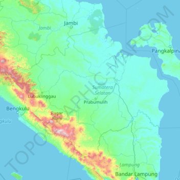
Name: South Sumatra topographic map, elevation, terrain.
Location: South Sumatra, Indonesia (-4.92416 102.05323 -1.51384 106.60263)
Average elevation: 123 m
Minimum elevation: -3 m
Maximum elevation: 2,774 m
Make a donation
Gear up for your next adventure:
As an Amazon Associate, this site earns from qualifying purchases at no extra cost to you.
Other topographic maps
Click on a map to view its topography, its elevation and its terrain.
Make a donation
Gear up for your next adventure:
As an Amazon Associate, this site earns from qualifying purchases at no extra cost to you.
Make a donation
Gear up for your next adventure:
As an Amazon Associate, this site earns from qualifying purchases at no extra cost to you.
Make a donation
Gear up for your next adventure:
As an Amazon Associate, this site earns from qualifying purchases at no extra cost to you.
Kopeng
Indonesia > Special Region of Yogyakarta > Sleman Regency > Kepuhharjo
Average elevation: 755 m
Make a donation
Gear up for your next adventure:
As an Amazon Associate, this site earns from qualifying purchases at no extra cost to you.
Make a donation
Gear up for your next adventure:
As an Amazon Associate, this site earns from qualifying purchases at no extra cost to you.
Make a donation
Gear up for your next adventure:
As an Amazon Associate, this site earns from qualifying purchases at no extra cost to you.
Make a donation
Gear up for your next adventure:
As an Amazon Associate, this site earns from qualifying purchases at no extra cost to you.
Make a donation
Gear up for your next adventure:
As an Amazon Associate, this site earns from qualifying purchases at no extra cost to you.
Make a donation
Gear up for your next adventure:
As an Amazon Associate, this site earns from qualifying purchases at no extra cost to you.
Make a donation
Gear up for your next adventure:
As an Amazon Associate, this site earns from qualifying purchases at no extra cost to you.
Make a donation
Gear up for your next adventure:
As an Amazon Associate, this site earns from qualifying purchases at no extra cost to you.
Make a donation
Gear up for your next adventure:
As an Amazon Associate, this site earns from qualifying purchases at no extra cost to you.
Make a donation
Gear up for your next adventure:
As an Amazon Associate, this site earns from qualifying purchases at no extra cost to you.
Make a donation
Gear up for your next adventure:
As an Amazon Associate, this site earns from qualifying purchases at no extra cost to you.
Kurnia Koto Salak
Indonesia > West Sumatra > Sungai Rumbai > Kurnia Koto Salak
Average elevation: 99 m
Make a donation
Gear up for your next adventure:
As an Amazon Associate, this site earns from qualifying purchases at no extra cost to you.
Dolok Sibualbuali
Indonesia > North Sumatra > South Tapanuli > Labuhan Rasoki
Average elevation: 1,504 m
Make a donation
Gear up for your next adventure:
As an Amazon Associate, this site earns from qualifying purchases at no extra cost to you.
Make a donation
Gear up for your next adventure:
As an Amazon Associate, this site earns from qualifying purchases at no extra cost to you.
Make a donation
Gear up for your next adventure:
As an Amazon Associate, this site earns from qualifying purchases at no extra cost to you.
Make a donation
Gear up for your next adventure:
As an Amazon Associate, this site earns from qualifying purchases at no extra cost to you.
Make a donation
Gear up for your next adventure:
As an Amazon Associate, this site earns from qualifying purchases at no extra cost to you.
Make a donation
Gear up for your next adventure:
As an Amazon Associate, this site earns from qualifying purchases at no extra cost to you.