Geolocate

Karangasem topographic map

Click on the map to display elevation.

About this map

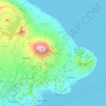
Name: Karangasem topographic map, elevation, terrain.

Location: Karangasem, Bali, Lesser Sunda Islands, Indonesia (-8.55092 115.39000 -8.16640 115.71150)

Average elevation: 381 m

Minimum elevation: 0 m

Maximum elevation: 3,007 m

Other topographic maps

Click on a map to view its topography, its elevation and its terrain.

Songan A

Indonesia > Bali > Bangli

Average elevation: 1,104 m

Bambu Indah Garden

Indonesia > Bali > Gianyar > Sayan

Average elevation: 189 m

Villa Mutiara

Indonesia > Bali > Klungkung Regency > Jungutbatu

Average elevation: 11 m

Gear up for your next adventure:

🏕️Camping Hammock - Integrated protection for sleeping between trees
🧥Waterproof Hiking Jacket - Protect yourself from rain and wind while hiking
🥾Hiking Shoes - Durable and comfortable shoes for trail hiking
💡Solar Camping Lamp - Eco-friendly lighting for campsites
🦌Outdoor Trail Camera - Monitor wildlife activity near your favorite spots

As an Amazon Associate, this site earns from qualifying purchases at no extra cost to you.