
Balikpapan topographic map
Click on the map to display elevation.
Balikpapan
Topography of Balikpapan is generally hilly (85%), with only small areas of flat land (15%), mostly along the coast and surrounding the hilly areas. The hills are less than 100 meters (330 feet) higher than the adjacent valleys. The altitude of Balikpapan ranges from 0 to 80 meters (260 feet) above sea level. The city proper itself is located on eastern side of Bay of Balikpapan.
About this map
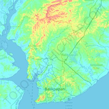
Name: Balikpapan topographic map, elevation, terrain.
Location: Balikpapan, East Kalimantan, Kalimantan, Indonesia (-1.28233 116.72880 -1.01330 117.02267)
Average elevation: 21 m
Minimum elevation: -5 m
Maximum elevation: 129 m
Other topographic maps
Click on a map to view its topography, its elevation and its terrain.