Geolocate

Kutai Timur topographic map

Click on the map to display elevation.

About this map

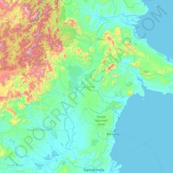
Name: Kutai Timur topographic map, elevation, terrain.

Location: Kutai Timur, East Kalimantan, Kalimantan, Indonesia (0.02250 115.96810 1.86814 118.98869)

Average elevation: 226 m

Minimum elevation: -3 m

Maximum elevation: 2,075 m

Gear up for your next adventure:

🏃Hydration Running Vest - Carry water and maps close to your body for speed
🪜Heavy Duty Carabiners - Multi-use clips for securing gear to your backpack
🚲Bike Repair Kit - Essential tools for on-trail mechanical issues
🐕Hiking Dog Pack - Let your canine companion carry their own water and food
🧤Insulated Winter Gloves - Heavy-duty protection for sub-zero Canadian adventures

As an Amazon Associate, this site earns from qualifying purchases at no extra cost to you.