Geolocate

Great Chart topographic map

Click on the map to display elevation.

About this map

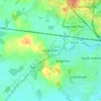
Name: Great Chart topographic map, elevation, terrain.

Location: Great Chart, Ashford, Kent, England, TN23 3AP, United Kingdom (51.12341 0.81217 51.16341 0.85217)

Average elevation: 49 m

Minimum elevation: 34 m

Maximum elevation: 87 m

Other topographic maps

Click on a map to view its topography, its elevation and its terrain.

Molash

United Kingdom > England > Kent > Ashford > Molash

Average elevation: 112 m

Crundale

United Kingdom > England > Kent > Ashford

Average elevation: 91 m

Challock

United Kingdom > England > Kent > Ashford > Challock

Average elevation: 136 m

Godmersham

United Kingdom > England > Kent > Ashford

Average elevation: 84 m

Biddenden

United Kingdom > England > Kent > Ashford

Average elevation: 46 m

Hastingleigh

United Kingdom > England > Kent > Ashford

Average elevation: 144 m

Bonnington

United Kingdom > England > Kent > Ashford

Average elevation: 17 m

Kenardington

United Kingdom > England > Kent > Ashford

Average elevation: 16 m

Eastwell

United Kingdom > England > Kent > Ashford

Average elevation: 81 m

Boughton Aluph

United Kingdom > England > Kent > Ashford > Boughton Lees

Average elevation: 78 m

Orlestone

United Kingdom > England > Kent > Ashford

Average elevation: 25 m

Biddenden

United Kingdom > England > Kent > Ashford

Average elevation: 46 m

Bilsington

United Kingdom > England > Kent > Ashford

Average elevation: 25 m

Ruckinge

United Kingdom > England > Kent > Ashford > Ruckinge

Average elevation: 23 m

Flip Out

United Kingdom > England > Kent > Ashford

Average elevation: 43 m

Shadoxhurst

United Kingdom > England > Kent > Ashford > Shadoxhurst

Average elevation: 43 m

Brook

United Kingdom > England > Kent > Ashford > Brook

Average elevation: 57 m

Wittersham

United Kingdom > England > Kent > Ashford

Average elevation: 18 m

Biddenden

United Kingdom > England > Kent > Ashford

Average elevation: 46 m

Charing

United Kingdom > England > Kent > Ashford > Charing

Average elevation: 122 m

Egerton

United Kingdom > England > Kent > Ashford > Egerton

Average elevation: 63 m

Upper Great Stour

United Kingdom > England > Kent > Ashford

Average elevation: 87 m

Hastingleigh

United Kingdom > England > Kent > Ashford

Average elevation: 144 m

Smarden

United Kingdom > England > Kent > Ashford

Average elevation: 31 m

Bethersden

United Kingdom > England > Kent > Ashford > Bethersden

Average elevation: 38 m

Woodchurch

United Kingdom > England > Kent > Ashford > Woodchurch

Average elevation: 28 m

High Halden

United Kingdom > England > Kent > Ashford > High Halden

Average elevation: 37 m

Hothfield

United Kingdom > England > Kent > Ashford > Hothfield

Average elevation: 61 m

Aldington

United Kingdom > England > Kent > Ashford > Aldington

Average elevation: 40 m

Warehorne

United Kingdom > England > Kent > Ashford

Average elevation: 20 m

Chilham

United Kingdom > England > Kent > Ashford

Average elevation: 72 m

Appledore

United Kingdom > England > Kent > Ashford

Average elevation: 9 m

Mersham

United Kingdom > England > Kent > Ashford

Average elevation: 55 m

Newenden

United Kingdom > England > Kent > Ashford

Average elevation: 10 m

Kingsnorth

United Kingdom > England > Kent > Ashford > Kingsnorth

Average elevation: 43 m

Rolvenden

United Kingdom > England > Kent > Ashford

Average elevation: 31 m

Stone-cum-Ebony

United Kingdom > England > Kent > Ashford

Average elevation: 12 m

Westwell

United Kingdom > England > Kent > Ashford > Westwell

Average elevation: 98 m

Gear up for your next adventure:

Camping Tent - Weather-resistant tents suitable for 2 to 6 people
🛰️Satellite Messenger - Emergency communication for areas with no cell service
🗺️Topographic Maps - Detailed maps to explore trails, mountains, and wilderness areas
🔥Camping Stove - Portable stoves to cook outdoors with ease
🪑Insulated Seat Pad - Protect your seat from cold rocks and wet logs

As an Amazon Associate, this site earns from qualifying purchases at no extra cost to you.