Geolocate

Hastingleigh topographic map

Click on the map to display elevation.

About this map

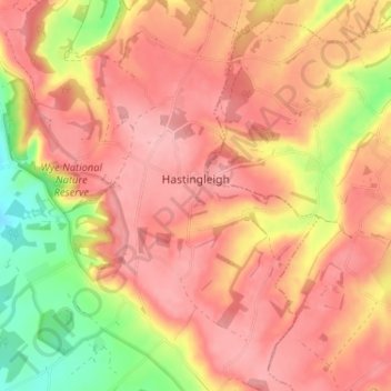
Name: Hastingleigh topographic map, elevation, terrain.

Location: Hastingleigh, Ashford, Kent, England, United Kingdom (51.14324 0.96793 51.18372 1.01689)

Average elevation: 144 m

Minimum elevation: 58 m

Maximum elevation: 189 m

Other topographic maps

Click on a map to view its topography, its elevation and its terrain.

Potters Corner

United Kingdom > England > Kent > Ashford

Average elevation: 61 m

Wye Downs

United Kingdom > England > Kent > Ashford

Average elevation: 118 m

Great Chart

United Kingdom > England > Kent > Ashford

Average elevation: 49 m

Aldington Frith

United Kingdom > England > Kent > Ashford

Average elevation: 44 m

St Michaels

United Kingdom > England > Kent > Ashford

Average elevation: 41 m

Stonestreet Green

United Kingdom > England > Kent > Ashford > Aldington

Average elevation: 57 m

Standen

United Kingdom > England > Kent > Ashford > Biddenden

Average elevation: 38 m

Flip Out

United Kingdom > England > Kent > Ashford

Average elevation: 43 m

Hassell Street

United Kingdom > England > Kent > Ashford > Hastingleigh

Average elevation: 134 m

Hamstreet

United Kingdom > England > Kent > Ashford

Average elevation: 22 m

Pluckley Thorne

United Kingdom > England > Kent > Ashford > Pluckley

Average elevation: 53 m

Old Wives Lees

United Kingdom > England > Kent > Ashford

Average elevation: 66 m

Wye

United Kingdom > England > Kent > Ashford

Average elevation: 55 m

Boughton Lees

United Kingdom > England > Kent > Ashford

Average elevation: 79 m

Stone Abbage

United Kingdom > England > Kent > Ashford

Average elevation: 47 m

Cheeseman's Green

United Kingdom > England > Kent > Ashford

Average elevation: 44 m

Stubbs Cross

United Kingdom > England > Kent > Ashford

Average elevation: 43 m

Small Hythe

United Kingdom > England > Kent > Ashford

Average elevation: 26 m

Egerton Forstal

United Kingdom > England > Kent > Ashford

Average elevation: 50 m

Stonebridge Green

United Kingdom > England > Kent > Ashford > Egerton

Average elevation: 80 m

Hinxhill

United Kingdom > England > Kent > Ashford

Average elevation: 51 m

Gear up for your next adventure:

👟Leg Gaiters - Keep debris, mud, and snow out of your boots
🧦Crew Hiking Socks - Comfortable socks for long-distance hikes
🧢Hiking Hat - Sun-protective and breathable hats for long treks
Camping Essentials - All-in-one gear for a comfortable camping trip
🔋Emergency Crank Radio - Weather alerts and power without needing batteries

As an Amazon Associate, this site earns from qualifying purchases at no extra cost to you.