Geolocate

Newenden topographic map

Click on the map to display elevation.

About this map

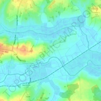
Name: Newenden topographic map, elevation, terrain.

Location: Newenden, Ashford, Kent, England, United Kingdom (51.01188 0.59582 51.02812 0.64829)

Average elevation: 10 m

Minimum elevation: -1 m

Maximum elevation: 39 m

Other topographic maps

Click on a map to view its topography, its elevation and its terrain.

Potters Corner

United Kingdom > England > Kent > Ashford

Average elevation: 61 m

Wye Downs

United Kingdom > England > Kent > Ashford

Average elevation: 118 m

Great Chart

United Kingdom > England > Kent > Ashford

Average elevation: 49 m

Aldington Frith

United Kingdom > England > Kent > Ashford

Average elevation: 44 m

St Michaels

United Kingdom > England > Kent > Ashford

Average elevation: 41 m

Stonestreet Green

United Kingdom > England > Kent > Ashford > Aldington

Average elevation: 57 m

Standen

United Kingdom > England > Kent > Ashford > Biddenden

Average elevation: 38 m

Flip Out

United Kingdom > England > Kent > Ashford

Average elevation: 43 m

Hassell Street

United Kingdom > England > Kent > Ashford > Hastingleigh

Average elevation: 134 m

Hamstreet

United Kingdom > England > Kent > Ashford

Average elevation: 22 m

Pluckley Thorne

United Kingdom > England > Kent > Ashford > Pluckley

Average elevation: 53 m

Old Wives Lees

United Kingdom > England > Kent > Ashford

Average elevation: 66 m

Wye

United Kingdom > England > Kent > Ashford

Average elevation: 55 m

Boughton Lees

United Kingdom > England > Kent > Ashford

Average elevation: 79 m

Stone Abbage

United Kingdom > England > Kent > Ashford

Average elevation: 47 m

Cheeseman's Green

United Kingdom > England > Kent > Ashford

Average elevation: 44 m

Stubbs Cross

United Kingdom > England > Kent > Ashford

Average elevation: 43 m

Small Hythe

United Kingdom > England > Kent > Ashford

Average elevation: 26 m

Egerton Forstal

United Kingdom > England > Kent > Ashford

Average elevation: 50 m

Stonebridge Green

United Kingdom > England > Kent > Ashford > Egerton

Average elevation: 80 m

Hinxhill

United Kingdom > England > Kent > Ashford

Average elevation: 51 m

Gear up for your next adventure:

🧣Evaporative Cooling Towel - Beat the heat during intense summer climbs
🔭Compact Binoculars - Lightweight optics for scouting trails and wildlife
🎒Hiking Backpack - Lightweight and ergonomic backpacks for day hikes or multi-day treks
Camping Tent - Weather-resistant tents suitable for 2 to 6 people
🥾Hiking Shorts - Breathable shorts suitable for summer hikes

As an Amazon Associate, this site earns from qualifying purchases at no extra cost to you.