
Make a donation
Gear up for your next adventure:
As an Amazon Associate, this site earns from qualifying purchases at no extra cost to you.
Chamoli District topographic map
Click on the map to display elevation.
Make a donation
Gear up for your next adventure:
As an Amazon Associate, this site earns from qualifying purchases at no extra cost to you.
Chamoli District
The geology of the region shows that the Himalayas are amongst the youngest mountains in the world. During early Mesozoic times the land mass now covered by them was occupied by the great Tethys sea. The probable date of the commencement of the elevation of the Himalayas is about the close of the Mesozoic era, but the unraveling of the story of their structure has only just begun, and in many cases no dating of the rocks is yet possible, though they include ancient and relatively recent crystalline intrusive, rocks and sediments allied to the peninsular part of India. The section of the range in the district is deeply cut into by the headwaters of the Allaknanda river, this trunk stream seeming to have reached a latter stage of development than its tributaries. This much, however, is known that there has been intense metamorphism. In some parts uplift has been considerable since the mid-Pleistocene epoch, in others there are great stretches of high but subdued topography and elsewhere there are the deepest gorges. The direction of folding in these mountain masses is generally North to South. The geological feature of the district form two major divisions which lies North and south of an imaginary line extending east-southeast between the villages of Hilang in Joshimath and Loharkhet in the adjoining District of Pithoragarh. The Northern division, which is occupied by higher ranges and snow-covered peaks consist entirely of medium to high grade metamorphic rocks and is intruded by later volcanic rocks. The division to the South, occupied by ranges of lower altitude, consists essentially of sedimentary and low grade metamorphic rock also intruded by later volcanic rocks. Geologically very little is known of the first division which consists of rocks such as quartzites, marbles and various types of micaceous schists and gneisses which a few sporadic occurrences of garnet, graphite, iron, kyanite, mica and vein quartz. The division to the south of the imaginary line is better known geologically and consists of rocks such as gneisses, limestone, phyllites, quartzite, sericite-biotite schists and slates.
Make a donation
Gear up for your next adventure:
As an Amazon Associate, this site earns from qualifying purchases at no extra cost to you.
About this map
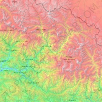
Name: Chamoli District topographic map, elevation, terrain.
Location: Chamoli District, Uttarakhand, India (29.92649 79.07727 31.07234 80.10295)
Average elevation: 3,712 m
Minimum elevation: 694 m
Maximum elevation: 7,653 m
Make a donation
Gear up for your next adventure:
As an Amazon Associate, this site earns from qualifying purchases at no extra cost to you.
Other topographic maps
Click on a map to view its topography, its elevation and its terrain.
Roorkee
India > Uttarakhand > Roorkee
Roorkee is located at 29°52′N 77°53′E / 29.87°N 77.88°E / 29.87; 77.88. It has an average elevation of 268 metres (879 ft).
Average elevation: 270 m
Make a donation
Gear up for your next adventure:
As an Amazon Associate, this site earns from qualifying purchases at no extra cost to you.
Make a donation
Gear up for your next adventure:
As an Amazon Associate, this site earns from qualifying purchases at no extra cost to you.
Make a donation
Gear up for your next adventure:
As an Amazon Associate, this site earns from qualifying purchases at no extra cost to you.
Make a donation
Gear up for your next adventure:
As an Amazon Associate, this site earns from qualifying purchases at no extra cost to you.
Make a donation
Gear up for your next adventure:
As an Amazon Associate, this site earns from qualifying purchases at no extra cost to you.
Make a donation
Gear up for your next adventure:
As an Amazon Associate, this site earns from qualifying purchases at no extra cost to you.
Gangolihāt
India > Uttarakhand > Gangolihat
Gangolihat is located at 29°29′N 80°03′E / 29.48°N 80.05°E / 29.48; 80.05. It has an average elevation of 1,760 metres (5,773 feet). It is 78 km from Pithoragarh. The main town is at a hill top. The region is surrounded by two rivers Saryu and Ramganga. Which meet at Ghat at the foothill of…
Average elevation: 1,532 m
Make a donation
Gear up for your next adventure:
As an Amazon Associate, this site earns from qualifying purchases at no extra cost to you.
Make a donation
Gear up for your next adventure:
As an Amazon Associate, this site earns from qualifying purchases at no extra cost to you.
Make a donation
Gear up for your next adventure:
As an Amazon Associate, this site earns from qualifying purchases at no extra cost to you.
Make a donation
Gear up for your next adventure:
As an Amazon Associate, this site earns from qualifying purchases at no extra cost to you.
Make a donation
Gear up for your next adventure:
As an Amazon Associate, this site earns from qualifying purchases at no extra cost to you.
Make a donation
Gear up for your next adventure:
As an Amazon Associate, this site earns from qualifying purchases at no extra cost to you.
Uttarkashi
India > Uttarakhand > Bhatwari
It is the district headquarters of Uttarkashi district. Uttarkashi is situated on the banks of river Bhagirathi at an altitude of 1158 m above sea level. Uttarkashi is generally known as a holy town close to Rishikesh. It is located in the state of Uttarakhand in India. Uttarkashi is home to a number of…
Average elevation: 1,619 m
Make a donation
Gear up for your next adventure:
As an Amazon Associate, this site earns from qualifying purchases at no extra cost to you.
Make a donation
Gear up for your next adventure:
As an Amazon Associate, this site earns from qualifying purchases at no extra cost to you.