Geolocate

Gamshali topographic map

Click on the map to display elevation.

About this map

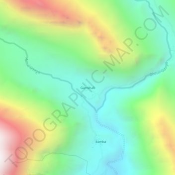
Name: Gamshali topographic map, elevation, terrain.

Location: Gamshali, Joshimath Tehsil, Chamoli, Uttarakhand, India (30.73600 79.80619 30.77600 79.84619)

Average elevation: 3,824 m

Minimum elevation: 3,141 m

Maximum elevation: 5,130 m

Other topographic maps

Click on a map to view its topography, its elevation and its terrain.

Mana

India > Uttarakhand > Joshimath Tehsil

Average elevation: 4,959 m

Saraswati

India > Uttarakhand > Joshimath Tehsil > Mana

Average elevation: 5,393 m

Gear up for your next adventure:

🥾Waterproof Hiking Boots - Boots keeping your feet dry in wet conditions
🚑Survival Whistle - Signal for help across long distances in mountains
🥾Mountain Hiking Boots - High-traction boots for rocky terrain
👟Leg Gaiters - Keep debris, mud, and snow out of your boots
🛏️Camping Sleeping Mat - Comfortable mats for sleeping outdoors

As an Amazon Associate, this site earns from qualifying purchases at no extra cost to you.