Geolocate

Cathedral Peak topographic map

Click on the map to display elevation.

About this map

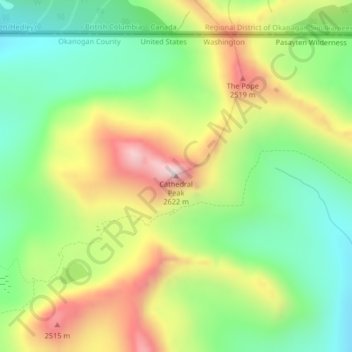
Name: Cathedral Peak topographic map, elevation, terrain.

Location: Cathedral Peak, Okanogan County, Washington, United States (48.98907 -120.18902 48.98917 -120.18892)

Average elevation: 2,231 m

Minimum elevation: 1,970 m

Maximum elevation: 2,606 m

Gear up for your next adventure:

🥾Trekking Boots - Durable boots for long-distance trekking
🩹Compact First Aid Kit - Pre-packed essentials for common trail injuries
🥾Light Trekking Boots - Supportive boots for multi-day treks
🌬️Windproof Camp Stove - Efficient cooking even on exposed mountain peaks
🧰Multitool Knife - Compact and versatile tool for outdoor use

As an Amazon Associate, this site earns from qualifying purchases at no extra cost to you.