Geolocate

University Place topographic map

Click on the map to display elevation.

About this map

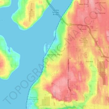
Name: University Place topographic map, elevation, terrain.

Location: University Place, Tacoma, Pierce County, Washington, 98466, United States (47.19680 -122.59207 47.27680 -122.51207)

Average elevation: 58 m

Minimum elevation: -1 m

Maximum elevation: 137 m

Other topographic maps

Click on a map to view its topography, its elevation and its terrain.

Waller

United States > Washington > Pierce County > Tacoma

Average elevation: 59 m

Gear up for your next adventure:

🥾Mountain Hiking Shoes - Shoes with superior grip for mountainous terrain
🔨Vehicle Emergency Tool - Safety tool for remote road trips to trailheads
🕶️Polarized Sunglasses - Protect your eyes with durable polarized lenses
👖Convertible Hiking Pants - Zip-off legs to adapt to changing weather conditions
🥾Trekking Boots - Durable boots for long-distance trekking

As an Amazon Associate, this site earns from qualifying purchases at no extra cost to you.