Geolocate

Copalis Crossing topographic map

Click on the map to display elevation.

About this map

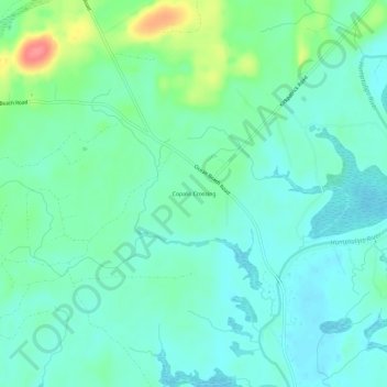
Name: Copalis Crossing topographic map, elevation, terrain.

Location: Copalis Crossing, Grays Harbor County, Washington, United States (47.08632 -124.09227 47.12632 -124.05227)

Average elevation: 21 m

Minimum elevation: 2 m

Maximum elevation: 77 m

Other topographic maps

Click on a map to view its topography, its elevation and its terrain.

Gear up for your next adventure:

🧥Insulated Jacket - Keep warm in cold outdoor conditions
🧰Multitool Knife - Compact and versatile tool for outdoor use
🧥Softshell Jacket - Windproof and breathable jacket for hiking
Camping Coffee Maker - Brew fresh coffee anywhere on the topographic map
🚲MTB Frame Bag - Carry tools and maps directly on your bicycle frame

As an Amazon Associate, this site earns from qualifying purchases at no extra cost to you.